Texas experiences a surge of spring-like weather with widespread showers and thunderstorms capable of producing hail and damaging winds. The storms are fueled by a Pacific cold front moving eastward, bringing heavy rain and the potential for severe weather to parts of the state.
Some of the widespread showers and thunderstorms that developed overnight across Texas will be capable of producing hail and damaging winds today. This weather pattern is more reminiscent of spring than late January. The storms have erupted along and ahead of a Pacific cold front . As the front continues eastward toward San Antonio, rain chances in South Texas will peak during the early to mid-morning hours. By the middle of the day, much drier air will move into the region.
Stronger storms will be possible to the north, from the Hill Country to parts of Central and North Texas. These areas will even have a chance of severe thunderstorms capable of delivering large hail, damaging winds and posing a small tornado threat. San Antonio’s highest chance of rain will arrive between 4 a.m. and 9 a.m. That’s when the Pacific cold front will move through the region. A few storms could become strong in Bexar County, capable of gusty winds, frequent lightning, and small hail. However, most storms will stay below the threshold to be considered severe weather. After 9 a.m., rain chances will decrease rapidly across South Texas as the line of storms moves off to the east. Severe thunderstorms will be possible for much of East Texas during the afternoon and early evening. Rainfall totals will be relatively light across South Texas. Much of Bexar County will receive between a quarter-inch and a half-inch of rain. Isolated locations, especially on the north side of San Antonio, could see up to an inch of rainfall. The Pacific cold front won’t necessarily lower temperatures much in our region, but it will bring much drier air. That means mostly sunny skies are expected over South Texas by Thursday afternoon, which should help temperatures warm up. San Antonio temps will be in the upper 60s at noon, rising slightly into the low 70s by the afternoon. Temperatures will fall back into the 60s after 5 p.m., but expect pleasant afternoon and evening weather outside. Warm weather continues Friday: Predawn temperatures will stay relatively chilly in the mid-40s, but another beautiful day with unseasonably warm temperatures is expected by the afternoon. Temps will make it to the low 70s again under mostly sunny skies. Winds will be light, coming in from the north at 5 to 10 mph. Weekend: If you don’t have any outdoor plans for the weekend, it’s time to make some because the weather will continue to be beautiful. After a chilly start on Saturday, afternoon temperatures will reach the low 70s once again by the afternoon. Sunday temps will be even warmer, reaching the mid- to upper 70s. Early next week The warmest of the next several days is expected to be next Monday. Temperatures will reach at least the upper 70s, with a chance to even reach the low 80s, under bright sunshine. A potential cold front could move into the region by Tuesday, but the exact timing and strength of the front is still uncertain
TEXAS WEATHER STORMS HAIL WIND COLD FRONT SEVERE WEATHER RAIN SAN ANTONIO
United States Latest News, United States Headlines
Similar News:You can also read news stories similar to this one that we have collected from other news sources.
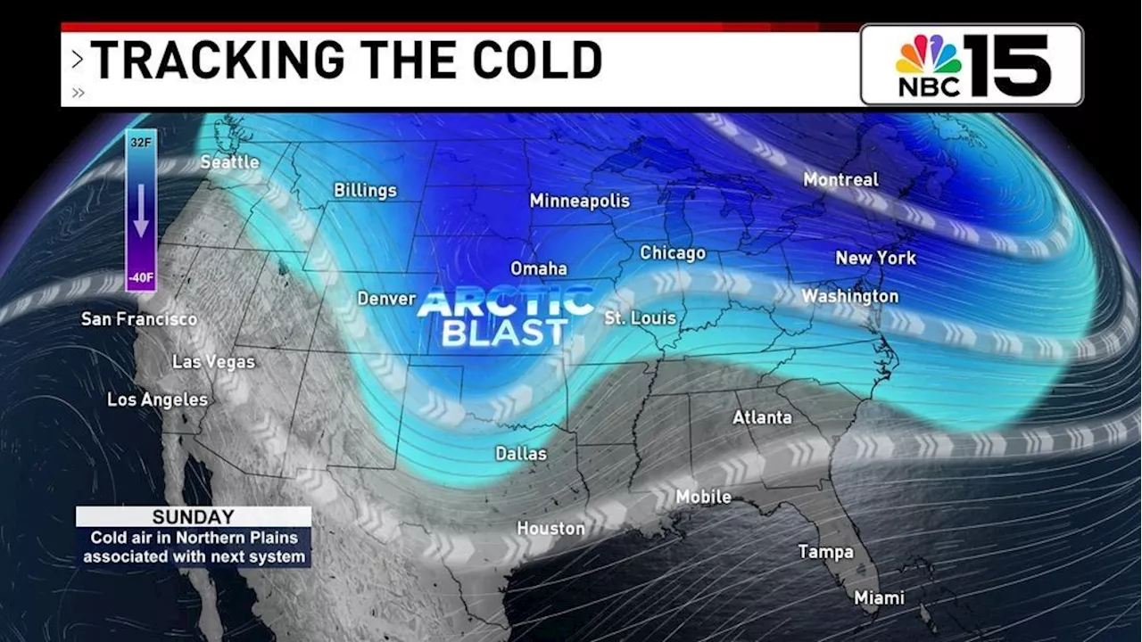 Chilly Start to Weekend, Strong Cold Front to Bring Severe StormsA cold front is approaching, bringing a chance of severe storms with damaging winds and a low risk of tornadoes.
Read more »
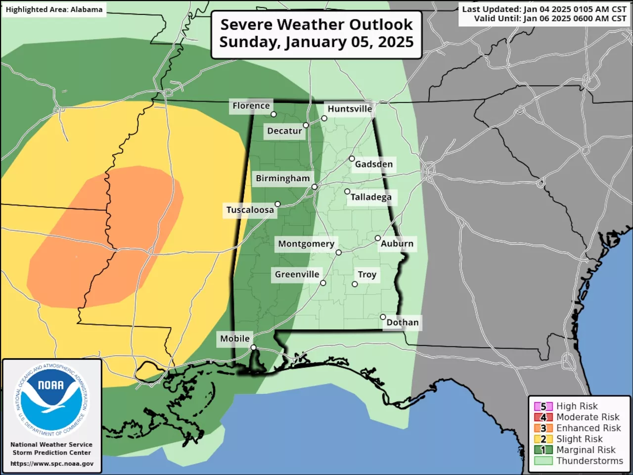 Strong Cold Front to Bring Rain, Storms and Cold Temperatures to Alabama SundayA strong cold front will sweep through Alabama on Sunday, bringing with it rain, strong storms, and a significant drop in temperatures. Parts of the state are at risk for severe weather.
Read more »
 Southerly Winds to Bring Warmer Air, Scattered Showers and Chance of StormsA weekend weather system will bring warmer air and scattered showers and thunderstorms to the region. While severe weather is not expected to be widespread, gusty winds and an isolated tornado remain possible. A cold spell is expected to follow the storm system, with temperatures dropping into the 20s and 30s throughout the week.
Read more »
 Powerful Storms Bring High Winds and Heavy Rain to AlaskaAlaska experiences a series of strong storms, bringing dangerous winds, heavy rain, and coastal flooding to various regions.
Read more »
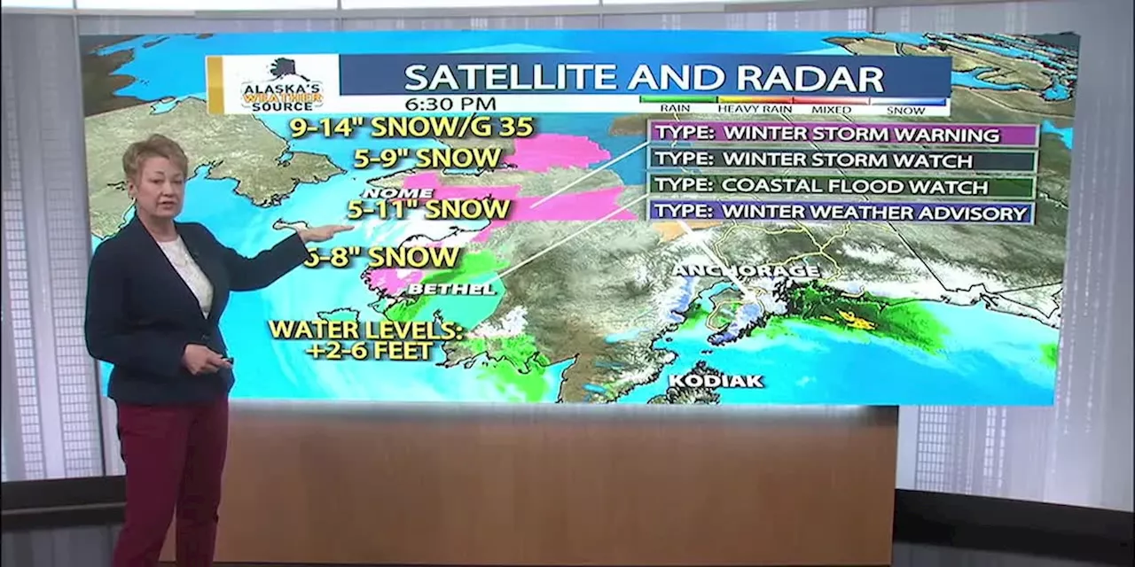 Winter storms bring a winter mixStorms are cycling through the state of Alaska with more than snow. Rain, gusty winds and mild temperatures are part of the winter storm parade.
Read more »
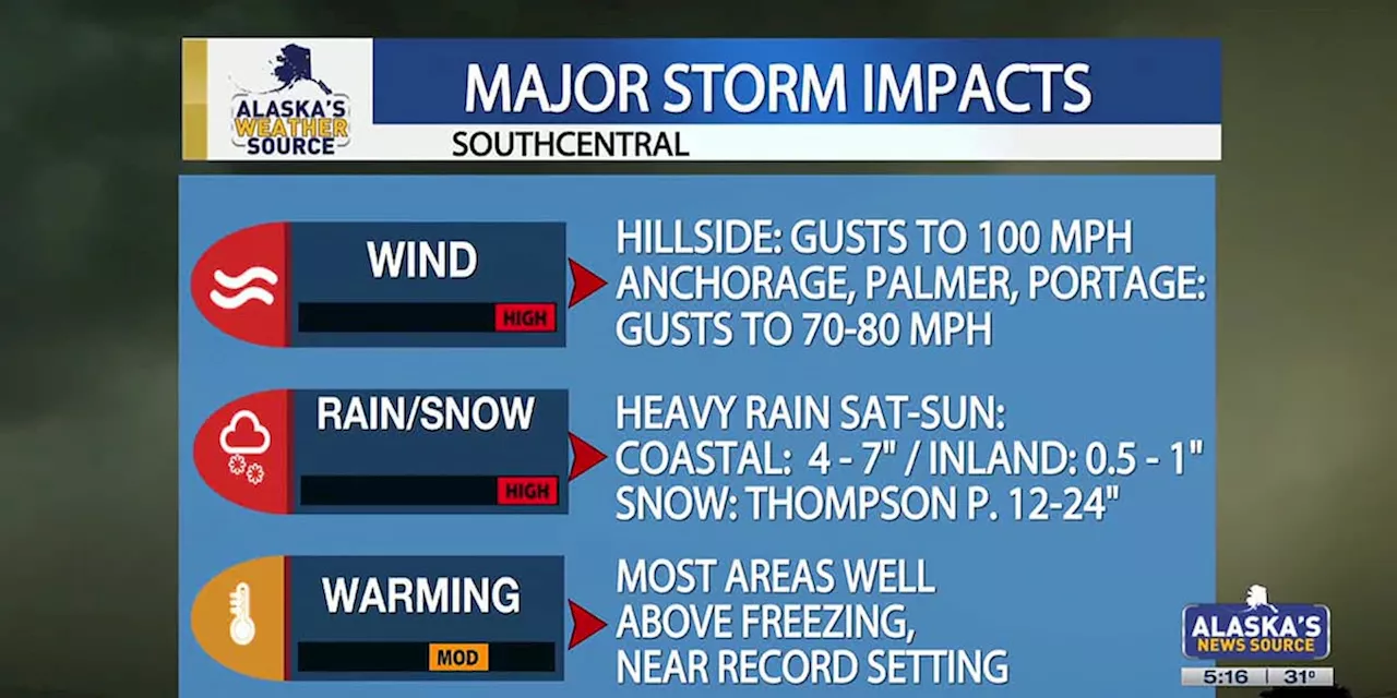
 High Wind Watch Issued for Anchorage as Back-to-Back Storms Bring Heavy Weather to AlaskaAlaska faces a barrage of storms with high winds, heavy rain, and snow expected across the state. Anchorage is under a high wind watch with gusts up to 70 mph possible. City officials are preparing for potential flooding due to rising creek levels and icy conditions. The storm is expected to bring heavy rain and a threat of flooding to Southcentral Alaska with warmer air pushing in. Avalanche danger is also increasing across the region.
Read more »