A weekend weather system will bring warmer air and scattered showers and thunderstorms to the region. While severe weather is not expected to be widespread, gusty winds and an isolated tornado remain possible. A cold spell is expected to follow the storm system, with temperatures dropping into the 20s and 30s throughout the week.
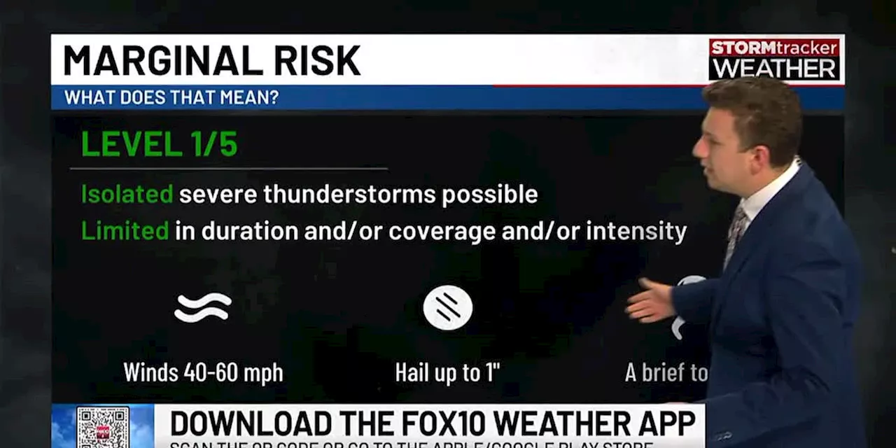
Southerly winds will usher in warmer air Sunday, bringing scattered showers and a few thunderstorms. Moisture return appears limited, so we’re not expecting widespread rain or significant severe weather . The Storm Prediction Center (SPC) has placed areas to our west under level one and two risks for severe storms. As these storms move into our area, limited instability should keep most below severe limits. However, the Storm Prediction Center maintains a marginal risk for severe storms.
The main threats will be gusty winds and an isolated tornado. Be sure to download the FOX10 Weather Apps for notifications on changing conditions. The main line of storms will pass after 10 PM Saturday night, likely clearing our northwest Florida counties by the pre-dawn hours Monday. Behind the line, strong northwesterly winds will usher in frigid air.Monday morning brings clearing skies and chilly conditions. Expect very brisk northwesterly winds around 20 mph with gusts to around 30 mph. Wind chill values may drop into the 20s at sunrise in some locations. Temperatures will struggle to rise, likely topping out in the middle 40s. Despite clear skies late in the day, it will remain unpleasantly cold—marking the beginning of a week-long cold spell for our region.Temperatures will remain cold all week. Afternoons will reach only the 40s while mornings dip into the 20s, bringing hard freezes to some areas. Many will need to protect outdoor plants and animals. Plumbing may be a concern in areas experiencing the coldest temperatures. The global forecast models—both the GFS and the European—now show a Gulf low moving across our area late in the week. While models still disagree on exact timing and track, there’s growing confidence that the low will develop. The low’s track and strength will determine our local precipitation impacts. While there’s still too much uncertainty for a definitive forecast, the most likely scenario brings cold rain to much of our area Friday into Saturda
WEATHER SEVERE WEATHER COLD SNAP GULF LOW FORECAST
United States Latest News, United States Headlines
Similar News:You can also read news stories similar to this one that we have collected from other news sources.
 Red flag warning across Southern California as Santa Ana winds bring dangerous fire conditionsMarlene Lenthang is a breaking news reporter for NBC News Digital.
Read more »
 Red flag warning across Southern California as Santa Ana winds bring dangerous fire conditionsMarlene Lenthang is a breaking news reporter for NBC News Digital.
Read more »
 Santa Ana winds bring Red Flag warnings for parts of Southern CaliforniaWinds are expected to pick up late Monday and get stronger through the night with peak winds arriving early Tuesday morning, according to KCAL News meteorologist Amber Lee.
Read more »
Santa Ana winds bring Red Flag warnings for parts of Southern CaliforniaWinds are expected to pick up late Monday and get stronger through the night with peak winds arriving early Tuesday morning, according to KCAL News meteorologist Amber Lee.
Read more »
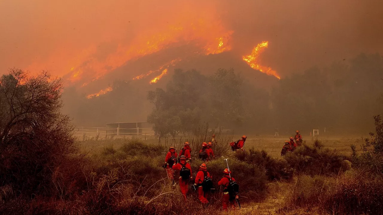 Thousands without power as Santa Ana winds bring increased fire risk for Southern CaliforniaPower to tens of thousands of people had been shut off by Monday night as utilities worked to mitigate the impacts of Southern California’s notorious Santa Ana winds, whose strong gusts could damage electrical equipment and spark wildfires.
Read more »
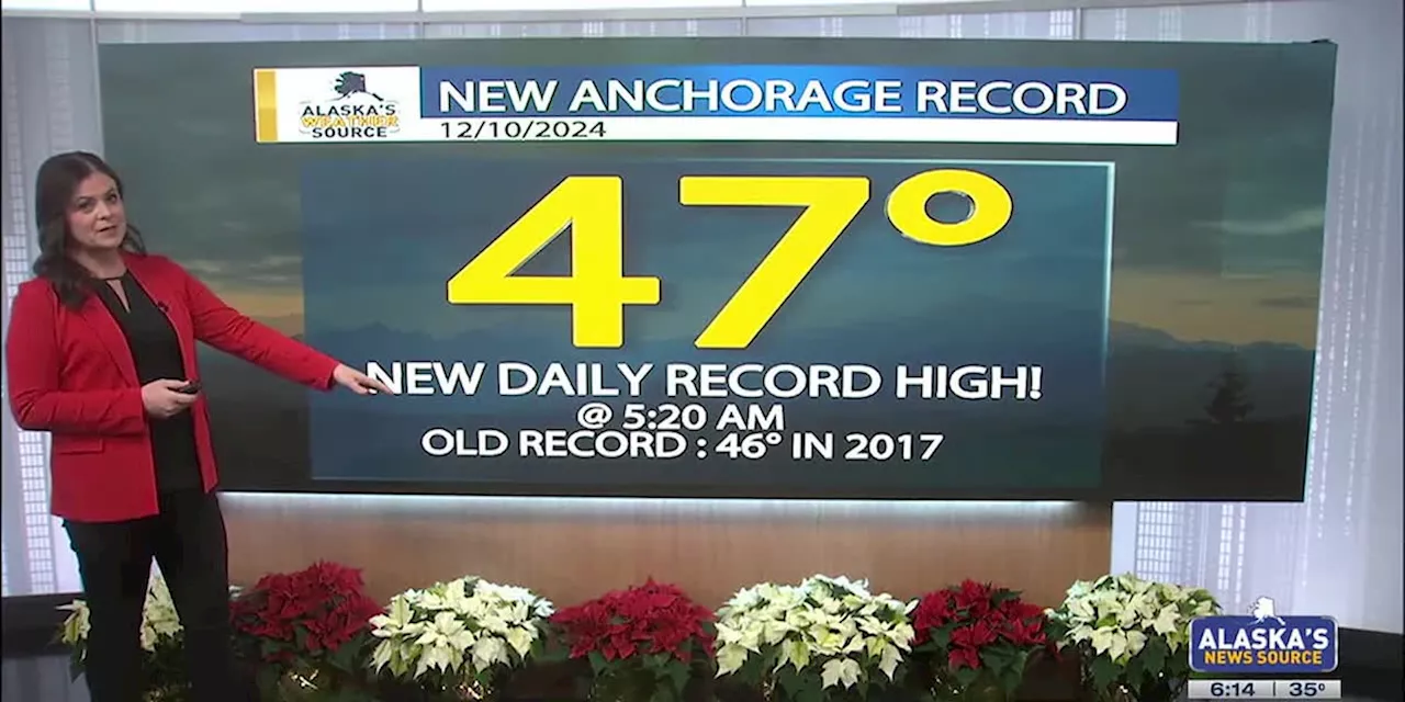 Winds bring in warm temperaturesA warm winter day for the entire state Tuesday. Anchorage topped out at 47 degrees at 5:20 am Tuesday, a result of the strong winds. That broke the old record of 46 degrees, set back in 2017. Change is coming though, with cold air wrapping back in and dropping temperatures below freezing again. And snow is likely later in the week.
Read more »