A breakthrough in satellite observations has allowed scientists to obtain high spatial resolution ozone profiles, enhancing our understanding of ozone distribution and its impact on the atmosphere. The research, conducted by the research team led by Cheng Liu and Fei Zhao at the University of Science and Technology of China, utilized data from the Environmental Trace Gases Monitoring Instrument (EMI) on the Gaofen-5 satellite, the first Chinese ultraviolet-visible hyperspectral spectrometer.
Ozone plays a crucial role in the atmosphere, and understanding its vertical distribution is key to comprehending its horizontal and vertical transport, as well as its physical and chemical properties. Satellite observations have emerged as one of the most effective methods for obtaining high-resolution ozone profiles. However, retrieving accurate ozone profiles using the EMI instrument poses unique challenges due to unavailable measurement errors and a low signal-to-noise ratio.
The retrieved ozone profiles showed maximum mean biases of 20% at five latitude bands. Moreover, when EMI averaging kernels were applied, the integrated stratospheric column ozone and tropospheric column ozone exhibited excellent agreement with ozonesonde data. Remarkably, the research not only unveiled the seasonal variation of surface ozone in the lower layers but also showcased distinct trends in the upper layers . In March, the ozone peak was found to occur at an altitude of 9.7–16.7 km, highlighting the intricate dynamics of ozone distribution.
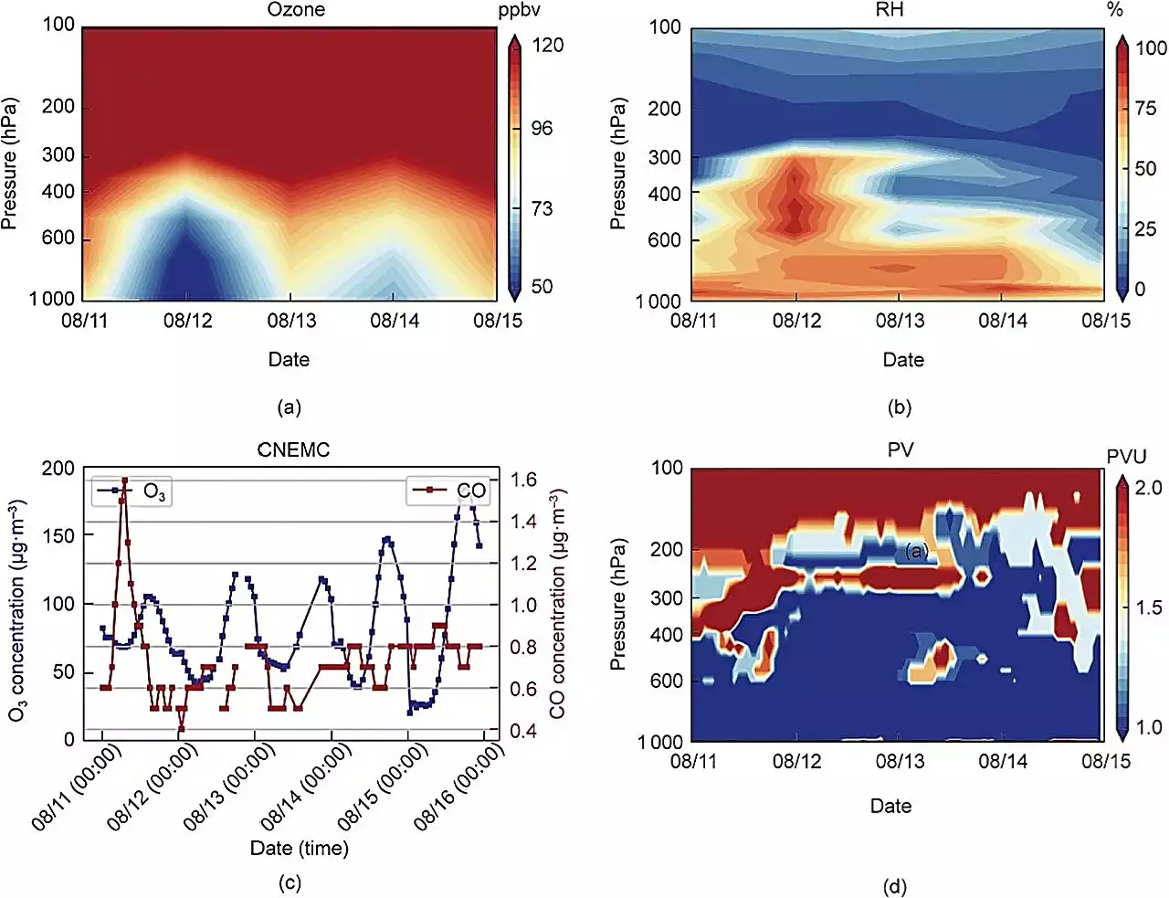
Furthermore, the EMI ozone profiles, alongside potential vorticity and relative humidity data, accurately captured a significant stratospheric intrusion event that occurred in central China from August 11 to 15, 2019. This event shed light on the downward transport mechanism that intensifies surface ozone pollution, as evidenced by an increase in ozone concentration observed by the China National Environmental Monitoring Center .
The researchers open up new avenues in understanding ozone distribution and its impact on Earth's atmosphere. Further advancements in
United States Latest News, United States Headlines
Similar News:You can also read news stories similar to this one that we have collected from other news sources.
 Emergency SOS via Satellite saves a woman and her dog from flash floodApple's Emergency SOS via Satellite saved the life of a woman and her dog when they got caught in a flash flood.
Read more »
 Osteoarthritis Breakthrough: New Therapeutic Approach DiscoveredAdvancements in understanding the disease could bring about a paradigm shift. For a long time, osteoarthritis was believed to stem from wear and tear in our later years. However, recent research increasingly connects the breakdown of cartilage to inflammatory and metabolic activities within the joi
Read more »
 Satellite images capture Hurricane Idalia's flooding in Florida's Big BendBefore Idalia, no major hurricanes on record had ever passed through the bay abutting the Big Bend.
Read more »
 A Satellite Deployed a Drag Sail and Removed Itself from Orbit Five Years EarlyA tiny satellite launched by Brown University students shows industry a low-cost way to remove satellites and space debris from orbit safely.
Read more »
 Satellite images show before and after Idalia flooded parts of FloridaMaxar satellite images show before and after Hurricane Idalia made landfall in Florida, flooding parts of the state's Big Bend region. The Category 3 storm left multiple areas across the Sunshine State under water and several residents stranded.
Read more »
 Satellite images show before and after Idalia flooded parts of FloridaMaxar satellite images show before and after Hurricane Idalia made landfall in Florida, flooding parts of the state's Big Bend region. The Category 3 storm left multiple areas across the Sunshine State under water and several residents stranded.
Read more »
