
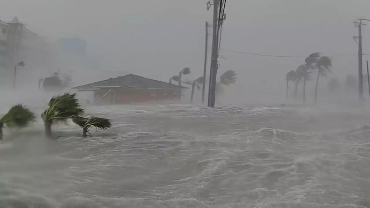
Tidal flooding from Ian was enough to close roads in the Riverside and San Marco neighborhoods on Friday afternoon.
We put the Sky 4 helicopter up to survey some of the flooding, and we also spotted floodwaters in the South Shores neighborhood and downtown in the Hogan’s Creek neighborhood.In 2017, the St. Johns River at the Main Street Bridge rose 2.7 feet, at which time the record flooding from Hurricane Irma began. The river eventually rose 3.5 feet, but there was also two feet of rain with that storm.
The river reached 2.7 feet from Ian on Thursday, but because of infrastructure improvements, Jacksonville averted another severe flooding event. These numbers were provided from the National Weather Service.Copyright 2022 by WJXT News4JAX - All rights reserved.
United States Latest News, United States Headlines
Similar News:You can also read news stories similar to this one that we have collected from other news sources.
 Riverside roads flood during Ian — but nothing compared to IrmaEveryone remembers the images of devastating flooding in Northeast Florida, including in the Riverside and Avondale area, during Hurricane Irma in 2017.
Read more »
 Hurricane Ian: Manatees at Spring Park fighting Hurricane Ian storm surge* LOCATIONS AFFECTED\n- Bonaire\n- Centerville\n- Clinchfield\n- Elberta\n- Elko\n- Grovania\n- Grove Park\n\n* WIND\n- LATEST LOCAL FORECAST: Below tropical storm force wind\n- Peak Wind Forecast: 15-25 mph with gusts to 45 mph\n\n- THREAT TO LIFE AND PROPERTY THAT INCLUDES TYPICAL FORECAST\nUNCERTAINTY IN TRACK, SIZE AND INTENSITY: Potential for wind 39\nto 57 mph\n- The wind threat has remained nearly steady from the\nprevious assessment.\n- PLAN: Plan for hazardous wind of equivalent tropical storm\nforce.\n- PREPARE: Remaining efforts to protect property should be\ncompleted as soon as possible. Prepare for limited wind\ndamage.\n- ACT: Move to safe shelter before the wind becomes hazardous.\n\n- POTENTIAL IMPACTS: Limited\n- Damage to porches, awnings, carports, sheds, and unanchored\nmobile homes. Unsecured lightweight objects blown about.\n- Many large tree limbs broken off. A few trees snapped or\nuprooted, but with greater numbers in places where trees\nare shallow rooted. Some fences and roadway signs blown\nover.\n- A few roads impassable from debris, particularly within\nurban or heavily wooded places. Hazardous driving\nconditions on bridges and other elevated roadways.\n- Scattered power and communications outages.\n\n* STORM SURGE\n- LATEST LOCAL FORECAST: Life-threatening storm surge possible\n- Peak Storm Surge Inundation: The potential for 4-6 feet\nabove ground somewhere within surge prone areas\n- Window of concern: through Friday evening\n\n- THREAT TO LIFE AND PROPERTY THAT INCLUDES TYPICAL FORECAST\nUNCERTAINTY IN TRACK, SIZE AND INTENSITY: Potential for storm\nsurge flooding greater than 3 feet above ground\n- The storm surge threat has remained nearly steady from the\nprevious assessment.\n- PLAN: Shelter against life-threatening storm surge of\ngreater than 3 feet above ground.\n- PREPARE: Flood preparations and ordered evacuations should\nbe complete. Evacuees should be in shelters well away from\nstorm surge flooding.\n- ACT: Remain shel
Read more »
 Hurricane Ian live updates: Hundreds of rescues in Florida as Ian eyes CarolinasLATEST: City of Sanibel officials said Thursday evening they have confirmed at least two fatalities. This brings the overall death toll from Ian to at least 11 that have been confirmed so far.
Read more »
 Hurricane Ian live updates: Ian makes landfall in South Carolina two days after first hitting FloridaIan made its second landfall near Georgetown, S.C. as a Category 1 hurricane on Friday afternoon.
Read more »
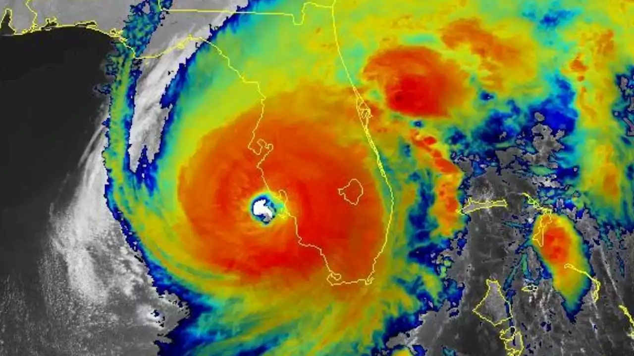 Hurricane Ian: Here's how an 'eyewall replacement cycle' turned Ian from a mess into a monsterLate Tuesday, Ian underwent what meteorologists call an eyewall replacement cycle, where the spiraling storm center contracts under intense pressure until it can no longer take the burden and collapses.
Read more »