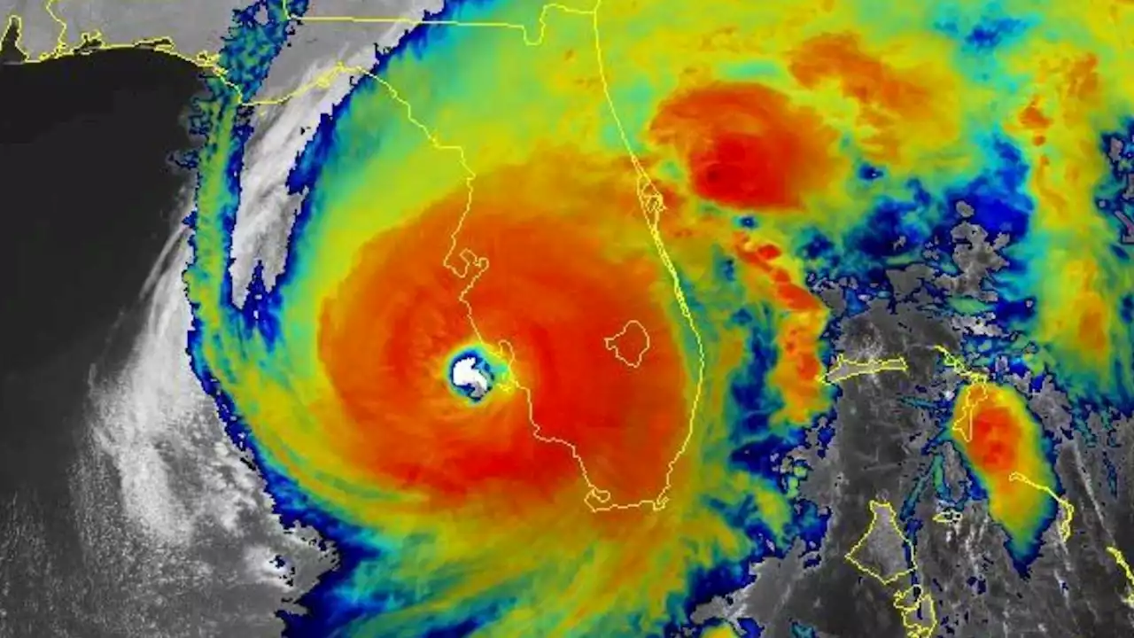
Late Tuesday, Ian underwent what meteorologists call an eyewall replacement cycle, where the spiraling storm center contracts under intense pressure until it can no longer take the burden and collapses.
As Ian channeled the surface heat of the ocean into energy, there was just more energy beneath it.
“When it came off of Cuba and got that perfect eyewall and it looked like Katrina, I knew it would be a classic Category 4 or 5 storm,” Weber said. Ian had a buffet of warm water leading it to Florida, no biting wind shear to tear it apart, steering winds tugged at it every so lightly, nudging it along at slow 9 to 10 mph and helping vent it like a flue in a chimney, adding to its power.
An average hurricane moves at about 12 to 14 mph, said meteorologist Jeff Masters, co-founder of Weather Underground and a writer for Yale Climate Connections.Masters said because Ian and Charley madeTen hours before landfall, Ian’s area of hurricane-force winds was 2.9 times larger than Charley. Jonathan Erdman, a meteorologist with The Weather Company, said Charley’s tropical storm-force wind field was about 125 nautical miles, whereas Ian’s was 290.
Masters said he was hoping Ian might mimic 2016’s Hurricane Matthew, which underwent an eyewall replacement cycle when it was a Category 4 colossus forecast to buzzsaw up Florida’s east coast. The cycle allowed dry air into the storm and may have helped wobble it away from the coast.“Matthew never recovered from its eyewall replacement cycle. Ian was able to recover and come ashore as a high-end Cat 4,” Masters said.
United States Latest News, United States Headlines
Similar News:You can also read news stories similar to this one that we have collected from other news sources.
 Hurricane Ian: Manatees at Spring Park fighting Hurricane Ian storm surge* LOCATIONS AFFECTED\n- Bonaire\n- Centerville\n- Clinchfield\n- Elberta\n- Elko\n- Grovania\n- Grove Park\n\n* WIND\n- LATEST LOCAL FORECAST: Below tropical storm force wind\n- Peak Wind Forecast: 15-25 mph with gusts to 45 mph\n\n- THREAT TO LIFE AND PROPERTY THAT INCLUDES TYPICAL FORECAST\nUNCERTAINTY IN TRACK, SIZE AND INTENSITY: Potential for wind 39\nto 57 mph\n- The wind threat has remained nearly steady from the\nprevious assessment.\n- PLAN: Plan for hazardous wind of equivalent tropical storm\nforce.\n- PREPARE: Remaining efforts to protect property should be\ncompleted as soon as possible. Prepare for limited wind\ndamage.\n- ACT: Move to safe shelter before the wind becomes hazardous.\n\n- POTENTIAL IMPACTS: Limited\n- Damage to porches, awnings, carports, sheds, and unanchored\nmobile homes. Unsecured lightweight objects blown about.\n- Many large tree limbs broken off. A few trees snapped or\nuprooted, but with greater numbers in places where trees\nare shallow rooted. Some fences and roadway signs blown\nover.\n- A few roads impassable from debris, particularly within\nurban or heavily wooded places. Hazardous driving\nconditions on bridges and other elevated roadways.\n- Scattered power and communications outages.\n\n* STORM SURGE\n- LATEST LOCAL FORECAST: Life-threatening storm surge possible\n- Peak Storm Surge Inundation: The potential for 4-6 feet\nabove ground somewhere within surge prone areas\n- Window of concern: through Friday evening\n\n- THREAT TO LIFE AND PROPERTY THAT INCLUDES TYPICAL FORECAST\nUNCERTAINTY IN TRACK, SIZE AND INTENSITY: Potential for storm\nsurge flooding greater than 3 feet above ground\n- The storm surge threat has remained nearly steady from the\nprevious assessment.\n- PLAN: Shelter against life-threatening storm surge of\ngreater than 3 feet above ground.\n- PREPARE: Flood preparations and ordered evacuations should\nbe complete. Evacuees should be in shelters well away from\nstorm surge flooding.\n- ACT: Remain shel
Read more »
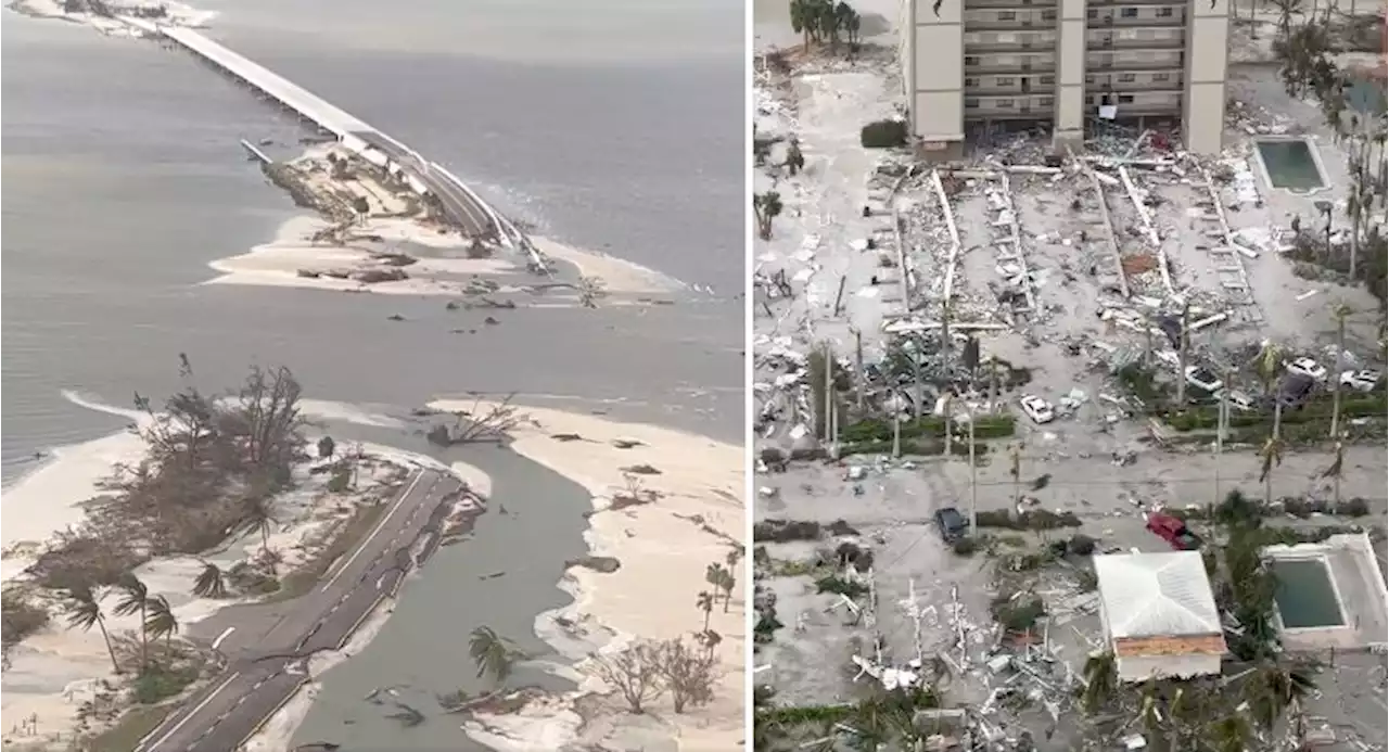 Aerial Video Shows Parts of Fort Myers, Florida, Decimated After Hurricane IanThe destruction was likened to a large tornado having barreled through, with homes and buildings 'completely gone.”
Read more »
 Fort Myers man found himself trapped after home flooded in Hurricane IanThe man's entire neighborhood, near the Caloosahatchee River in North Fort Myers, was flooded and he worried his neighbors in single-story homes didn't evacuate.
Read more »
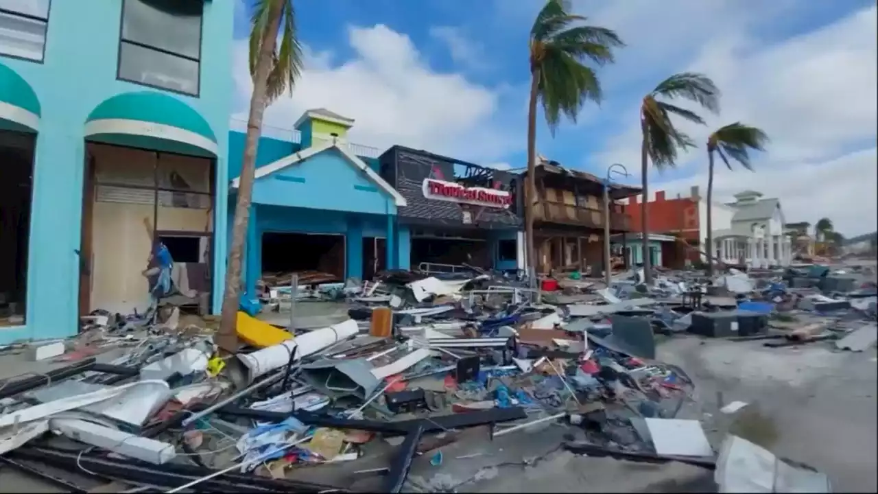 Video: Hurricane Ian wipes out Fort Myers Beach, FloridaIt’s one of several barrier islands in southwest Florida that were hit hardest by Ian’s wrath.
Read more »