A series of cold fronts is set to sweep through South Texas over the next week, bringing frigid temperatures and a chance of light precipitation. Temperatures will plummet below average, with the potential for widespread freezing conditions by mid-week next week.
A strong cold front swept through South Texas Wednesday evening, ushering in frigid air from the north. This active weather pattern is just the beginning, with a series of cold front s anticipated to cross South Texas over the next week. In between these fronts, spring-like temperatures are expected to make brief appearances. Thursday morning will usher in a bitterly cold start, with temperatures in the mid- to upper 30s between 4 am and 9 am.
San Antonio is expected to hover just above freezing, with a low between 34 and 37 degrees. Parts of the Hill Country, however, will experience a light freeze, with lows ranging from 29 to 32 degrees from Fredericksburg to Kerrville. Strong north winds at 15 to 20 mph, with gusts potentially reaching 30 mph, will further exacerbate the chill, sending wind chill values as low as 25 to 28 degrees in San Antonio and the upper teens across the Hill Country.Temperatures will remain chilly throughout the day Thursday, with mostly cloudy skies and persistent northerly winds. San Antonio will see a gradual rise to the low 40s between 10 and 11 am, eventually topping out in the mid- to upper 40s by late afternoon. This marks a significant drop from the climate-normal for mid-February. There's a slight chance of isolated showers or drizzle in South Texas from morning through early afternoon, but any rainfall will be light and minimal, amounting to only a few hundredths of an inch. Friday will bring more of the same, with mostly cloudy skies keeping temperatures well below average. Morning lows will settle around 40 degrees, and afternoon highs are expected to reach only the upper 40s to low 50s. A few showers and patches of drizzle remain possible throughout the day. Once again, rainfall amounts will be light. Saturday will bring a dramatic shift, with drier air and increased sunshine leading to afternoon highs in the mid- to upper 70s. Areas closer to the Rio Grande could even see temperatures reaching the low 80s. However, this warmth won't last long. Another cold front is expected to sweep through late Saturday or early Sunday, quickly dropping temperatures back into the upper 30s to low 40s Sunday morning. Afternoon highs will only reach the mid-50s, with a light freeze possible as far south as San Antonio by early Sunday. This pattern of cold fronts will continue next week, with weather models predicting another front to move through South Texas late Tuesday or early Wednesday. This front has the potential to bring even colder air, possibly causing widespread freezing by Wednesday or Thursday morning. There's still significant uncertainty surrounding this front, including whether or not it will produce precipitation.
COLD FRONT SOUTH TEXAS WEATHER FORECAST FREEZE CHILLY TEMPERATURES WIND CHILL
United States Latest News, United States Headlines
Similar News:You can also read news stories similar to this one that we have collected from other news sources.
South Texas Weather: Chilly Weekend Ahead, Heavy Rain Possible Next WeekWhile the arctic air has moved out of South Texas, the weekend will be chilly with below-average temperatures and light rain. Next week will bring warmer temperatures, a cold front, and a high chance of heavy precipitation, including thunderstorms.
Read more »
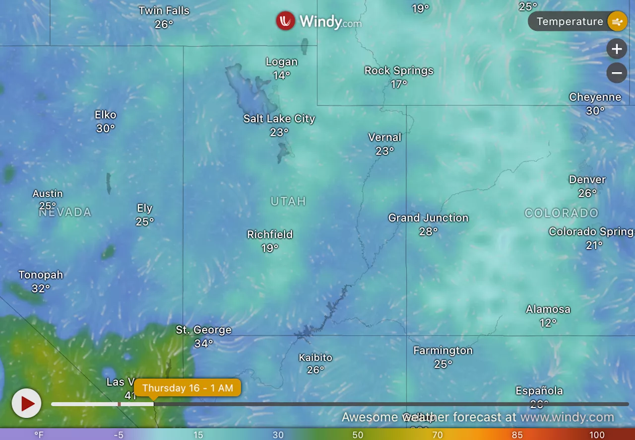 Utah Braces for Chilly Temperatures: Winter Weather Pattern Grips the StateUtah is experiencing a significant cold spell this week, with temperatures far below the historical average. This unusual weather pattern underscores the broader trend of extreme winter conditions affecting much of the United States. Residents and visitors are advised to take precautions against the cold and stay informed about potential weather changes.
Read more »
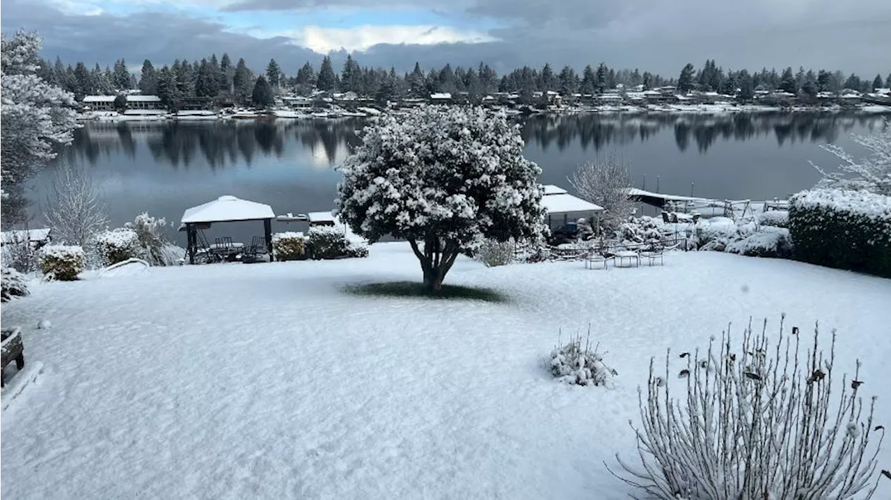
 Western Washington Braces for Chilly Holiday WeekendWestern Washington is set to experience its coldest weather of the season, with temperatures dropping significantly starting this holiday weekend and continuing into next week. A persistent high-pressure system is keeping Pacific weather systems at bay, resulting in a prolonged dry spell and limited rainfall. Temperatures are struggling to reach the lower 40s due to a strong temperature inversion. While some sunshine is expected, overnight lows will dip into the 20s and 30s. The mountain snowpack is also experiencing a slowdown due to the lack of precipitation.
Read more »
 Ohio Braces for Chilly Weather; Woman Sentenced in Casino Security Guard's DeathThis news report covers two separate events: a Cold Weather Advisory issued for all of Ohio and the sentencing of Lyndsey Wilcox in connection with the death of Genesee County Sheriff's Office Sergeant Thomas Sanfratello at Batavia Downs.
Read more »
 Law Bird Makes James Beard Semi-Finals As Ohio Braces for Chilly WeatherLaw Bird, a celebrated bar program, has been named a Semi-Finalist for the prestigious James Beard Foundation Award for Outstanding Bar Program. This recognition comes as Ohio faces a cold weather advisory with wind chills potentially reaching -20 degrees Fahrenheit.
Read more »
 Western Washington Braces for Chilly Conditions and Continued SnowThe snow in Western Washington has transitioned to cold temperatures and icy conditions. Forecasters predict temperatures will remain in the mid-20s through Friday, with a slight warm-up to around 30 degrees by Saturday. The Cascades have seen significant snowfall, and snow showers are expected to continue throughout the week, posing challenges for driving due to reduced visibility.
Read more »