A major shift in weather patterns will bring rain, cooler temperatures, and a chance of lowland snow to the Puget Sound region through the next week.
Thursday will be a transitional day as a significant shift in the weather pattern ushers in a period of rain, cooler temperatures , and a possibility of lowland snow extending into next week. Here's a breakdown of the daily forecast:Thursday will be mostly dry and cloudy with cooler high temperatures reaching around 44 degrees. The first notable frontal system in weeks will move in later this evening, bringing widespread rain and mountain snow.
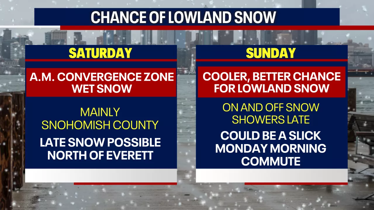
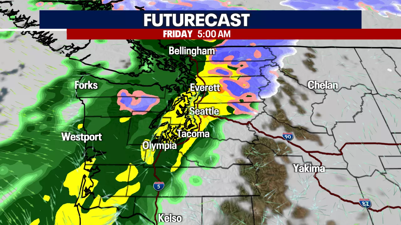
Snow levels will range between 3,000 and 4,000 feet tonight. Travel over the Cascades will be challenging for the next two days. Accumulations of one to two feet of snow are possible over the mountain passes (Stevens, Snoqualmie, White, and Blewett) through Saturday.Widespread rain showers and mountain snow will persist throughout most of Friday. Daytime temperatures will warm up close to 50 degrees. Late Friday night into early Saturday morning, there's a chance for wet convergence zone snow to reach the lowland areas of Snohomish or north King counties. The likelihood of snow versus rain will be marginal, with snow levels and temperatures hovering in the low to mid-30s. Remember, a difference of just 2 to 3 degrees can significantly impact whether precipitation falls as rain or snow. After sunrise on Saturday, most areas will experience light rain showers as temperatures rise. Another opportunity for lowland snow showers is expected Saturday night as temperatures drop. The highest chance for lowland snow in the Puget Sound area Saturday evening will be north of Everett.Temperatures will continue to decline on Sunday as winds from the Fraser Valley strengthen and colder air moves into the Puget Sound region. By Sunday evening, temperatures should be cold enough in the Puget Sound area for snow. While precipitation is expected to be somewhat limited, any scattered showers that fall Sunday night and Monday morning will likely be snow. It will be crucial to monitor the forecast in the coming days, as Monday morning's commute could be affected. Temperatures will remain very chilly next week, with daytime highs in the mid-30s and overnight lows dipping into the mid-20s. While a widespread snowstorm is not anticipated, any light showers during the week could produce additional snow. An offshore low-pressure system will send scattered showers inland. We will have a clearer understanding of accumulation amounts as we approach the weekend and higher-resolution weather models become available. Although this is not expected to be a major snow event for the area, anyone in the greater Puget Sound region could experience some snowfall from Saturday morning through the middle of next week
WEATHER SNOW RAIN COOLER TEMPERATURES PUGET SOUND FORECAST
United States Latest News, United States Headlines
Similar News:You can also read news stories similar to this one that we have collected from other news sources.
 Puget Sound to See Dry Thursday, Rain Returns FridayThe Puget Sound area will enjoy dry conditions with sunshine on Thursday, but rain is expected overnight. Mountain snow is also possible.
Read more »
 Northeast Ohio Weather Forecast: Snow Showers Expected Wednesday, Rain and Wet Snow Likely FridayA quick-moving cold front will bring snow showers to northeastern Ohio on Wednesday, followed by rain and wet snow on Friday. Temperatures will warm up briefly on Thursday before dropping again over the weekend.
Read more »
 Boaters Urged to Give Space to Endangered Orcas in Puget SoundA new law in Washington state requires boaters to stay 1,000 yards away from Southern Resident killer whales (SRKW) at all times. Experts say this distance is crucial to protecting the endangered population, which is struggling due to declining salmon populations and increasing human disturbance.
Read more »
 Washingtonians Warned About King Tides Expected to Hit South Puget SoundKing tides, caused by an amplified gravitational pull between the Earth and moon, are expected to hit South Puget Sound on January 4-6. The Thurston Conservation District warns that these high tides, coupled with high precipitation, could lead to flooding and property damage. The tides serve as a reminder of the realities of climate change and its long-term challenges.
Read more »
 Endangered Orca Carries Dead Calf in Puget SoundTahlequah, a Pacific Northwest orca known for carrying her dead calf in 2018, has been observed doing so again after the death of her new calf. Researchers say this behavior is another sign of grief over lost offspring.
Read more »
 Puget Sound Pet Food Bank saved from closure by generous donors' timely supportThe Puget Sound Pet Food Bank, a vital resource for families and their pets in Pierce County, has been saved from closure.
Read more »