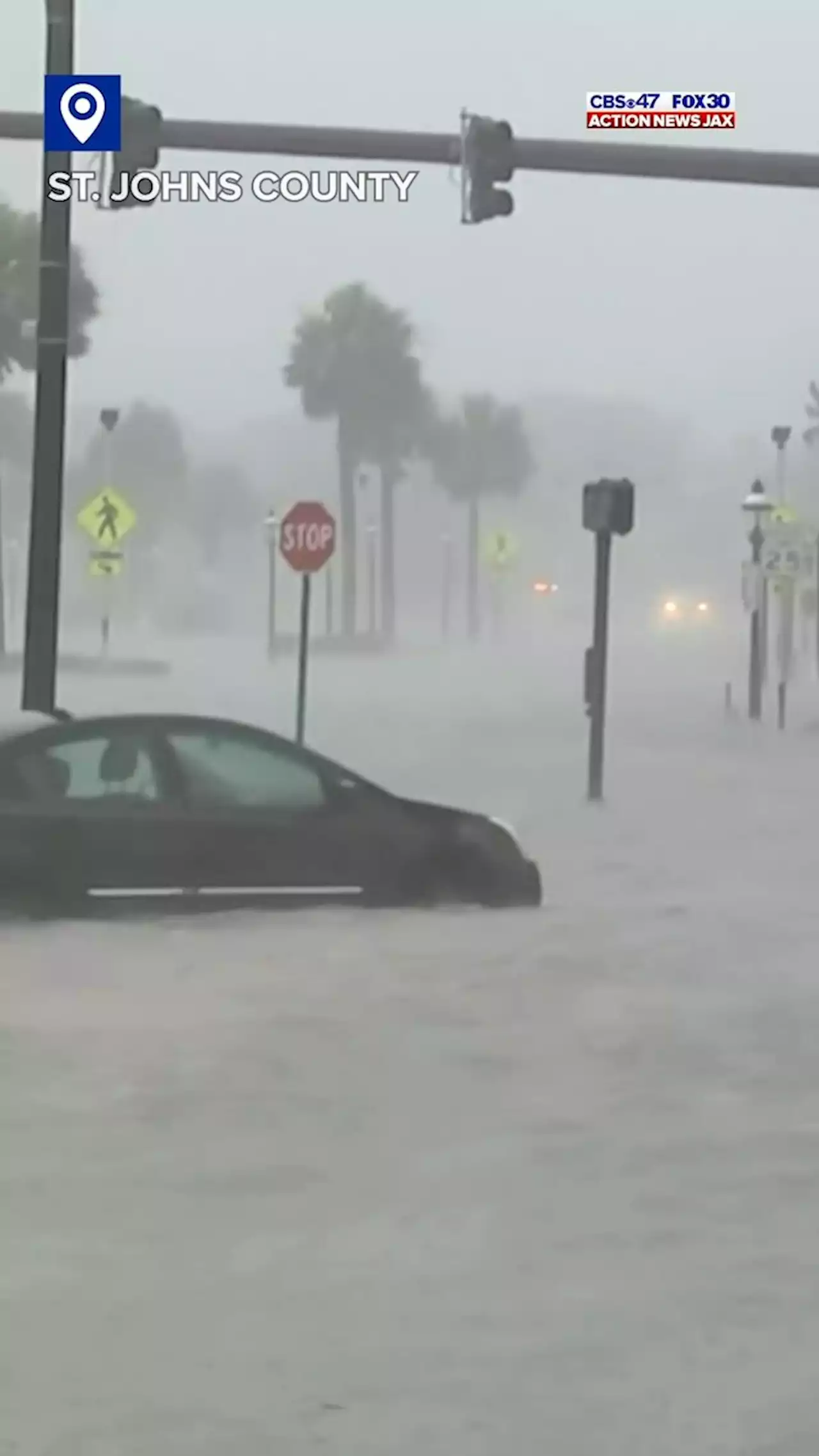
Action News Jax's Ben Becker traveled to St. Augustine Beach to cover Hurricane Ian, battling the mass sea foam
, we are watching closely to determine if evacuations in Zone A is the safest option for citizens. We will make this decision early Wednesday morning, but if you live in Zone A please be prepared for this possible scenario.”Camden County Board of Commissioners have issued a State of Emergency Declaration effective Tuesday until rescinded. Officials from the Camden County Board of Commissioners and the Cities of Kingsland, St.
Thursday and Friday, Duval schools will close. The Oct. 14th weather day will be a regular school day.Several Northeast Florida cities and counties will be giving news conferences about preparations ahead of Hurricane Ian. Action News Jax will stream all of them and they are as follows:Clay County Emergency Management at 2:30 p.m.Tropical storm watches placed on Bradford County, Western Duval County, Western Clay County and Western Putnam County.2:39 a.m.
Duval County Public Schools Superintendent Dr. Diana Greene Duval County Public Schools said Tuesday will be a normal school day. Wednesday is already scheduled early release. A decision about any potential closures this week will be made by Tuesday at noon. Residents can find tips and resources such as supply kits, pets, and other emergency response information atJEA leadership is closely monitoring Hurricane Ian to ensure the utility’s readiness for the storm. JEA Managing Director & CEO Jay Stowe ordered JEA’s Emergency Operations Center to operate at partial Activation status.
account and to sign up for voice, email or text alerts. This will allow JEA to contact customers directly with updates on a power outage.Storm Hardening
United States Latest News, United States Headlines
Similar News:You can also read news stories similar to this one that we have collected from other news sources.
 Jacksonville News, Weather, Traffic and Sports – Action News Jax* LOCATIONS AFFECTED\n- Jekyll Island\n- Glynn Haven\n- Sea Island\n- St. Simons\n- Country Club Estate\n- Dock Junction\n\n* WIND\n- LATEST LOCAL FORECAST: Equivalent Tropical Storm force wind\n- Peak Wind Forecast: 35-45 mph with gusts to 70 mph\n- Window for Tropical Storm force winds: until Friday morning\n\n- THREAT TO LIFE AND PROPERTY THAT INCLUDES TYPICAL FORECAST\nUNCERTAINTY IN TRACK, SIZE AND INTENSITY: Potential for wind 58\nto 73 mph\n- The wind threat has remained nearly steady from the\nprevious assessment.\n- PLAN: Plan for dangerous wind of equivalent strong tropical\nstorm force.\n- PREPARE: Last minute efforts to protect life and property\nshould now be complete. The area remains subject to\nsignificant wind damage.\n- ACT: Now is the time to shelter from dangerous wind.\n\n- POTENTIAL IMPACTS: Unfolding\n- Potential impacts from the main wind event are unfolding.\n\n* STORM SURGE\n- LATEST LOCAL FORECAST: Life-threatening storm surge possible\n- Peak Storm Surge Inundation: The potential for 4-6 feet\nabove ground somewhere within surge prone areas\n- Window of concern: through Friday evening\n\n- THREAT TO LIFE AND PROPERTY THAT INCLUDES TYPICAL FORECAST\nUNCERTAINTY IN TRACK, SIZE AND INTENSITY: Potential for storm\nsurge flooding greater than 3 feet above ground\n- The storm surge threat has remained nearly steady from the\nprevious assessment.\n- PLAN: Shelter against life-threatening storm surge of\ngreater than 3 feet above ground.\n- PREPARE: Flood preparations and ordered evacuations should\nbe complete. Evacuees should be in shelters well away from\nstorm surge flooding.\n- ACT: Remain sheltered in a safe location. Do not venture\noutside.\n\n- POTENTIAL IMPACTS: Unfolding\n- Potential impacts from the main surge event are unfolding.\n\n* FLOODING RAIN\n- LATEST LOCAL FORECAST: Flood Watch is in effect\n- Peak Rainfall Amounts: Additional 1-3 inches, with locally\nhigher amounts\n\n- THREAT TO LIFE AND PROPERTY THAT INCLUDES TYPICAL FORE
Read more »
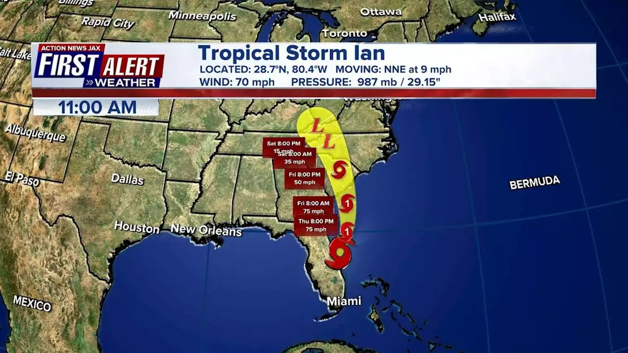 Tropical Storm Ian: Storm forecast to become hurricane again once it is off our coastIAN UPDATE: The latest track shows Ian is forecast to become a hurricane again once it is off of our coast
Read more »
 Tropical Storm Ian live updates: Biden approves Florida disaster declarationThe Action News Jax First Alert Weather Team is continuing to track Hurricane Ian.
Read more »
 Action News Special Report: Emerging drug 'Tranq' leading to amputationsBrooke Peder showed us her wounds. She has already had a leg amputated and now she's worried she may lose an arm.
Read more »
 Carjackings double over last year in Philadelphia, data obtained by Action News showsThere have been more than 1,000 carjackings year to date, compared to fewer than 500 at the same point in 2021.
Read more »
 'Jim Gardner Way': City Council introduces resolution to honor Action News anchorA resolution introduced Thursday would rename the stretch of Monument Road-- outside Action News studios-- to 'Jim Gardner Way.'
Read more »