
Explore the USGS collection of audio includes podcasts, interviews, and sounds.
Eyes on Earth is a podcast on remote sensing, Earth observation, land change and science, brought to you by the USGS Earth Resources Observation and Science Center. The USGS Sounds of Yellowstone series lets you listen the natural sounds of geysers, hot springs, and mudpots found through Yellowstone National Park in Wyoming, USA.
Also on YouTube , Apple and Google Podcasts.Eyes on Earth Episode 129 – What Happens During a Landsat Pass?Eyes on Earth Episode 129 – What Happens During a Landsat Pass? In this episode of Eyes on Earth, we talk to ground station technicians to find out how Landsat satellite data gets from the spacecraft to EROS and then to the archive. We see what it’s like in EROS’s Landsat operations room and what the technicians do before, during, and after a Landsat pass.In this episode of Eyes on Earth, we talk to ground station technicians to find out how Landsat satellite data gets from the spacecraft to EROS and then to the archive. We see what it’s like in EROS’s Landsat operations room and what the technicians do before, during, and after a Landsat pass.In this episode of Eyes on Earth, we mingle at the 2024 EROS Fall Poster Session. A poster session is essentially a way for scientists to share their work with their colleagues in a public forum. About 30 posters were on display in the EROS atrium from EROS staff and several students from South Dakota State University and the University of South Dakota.In this episode of Eyes on Earth, we mingle at the 2024 EROS Fall Poster Session. A poster session is essentially a way for scientists to share their work with their colleagues in a public forum. About 30 posters were on display in the EROS atrium from EROS staff and several students from South Dakota State University and the University of South Dakota.In this episode of Eyes on Earth, we talk about the incredible career of Landsat 7, which collected science imagery of the Earth for nearly 25 years. The Flight Operations Team at NASA Goddard Space Flight Center and engineers at EROS work together to collect imagery, send commands to the satellite, and keep it healthy.In this episode of Eyes on Earth, we talk about the incredible career of Landsat 7, which collected science imagery of the Earth for nearly 25 years. The Flight Operations Team at NASA Goddard Space Flight Center and engineers at EROS work together to collect imagery, send commands to the satellite, and keep it healthy.In this episode of Eyes on Earth, we talk about the latest release of the National Land Cover Database . More than just a map, NLCD is a stack of maps—a database. It has long been the foundational land cover source for scientists, resource managers, and decision-makers across the United States, and now the next generation of USGS land cover mapping is here.In this episode of Eyes on Earth, we talk about the latest release of the National Land Cover Database . More than just a map, NLCD is a stack of maps—a database. It has long been the foundational land cover source for scientists, resource managers, and decision-makers across the United States, and now the next generation of USGS land cover mapping is here.In this episode of Eyes on Earth, we talk about the Landscape Fire and Resource Management Planning Tools project, which is commemorating its 20th year of providing geospatial data to support natural resource management and wildland fire planning. LANDFIRE brings a lot of data together, over 30 data products, into one place.In this episode of Eyes on Earth, we talk about the Landscape Fire and Resource Management Planning Tools project, which is commemorating its 20th year of providing geospatial data to support natural resource management and wildland fire planning. LANDFIRE brings a lot of data together, over 30 data products, into one place.In this episode of Eyes on Earth, we talk to forest ecologist Jim Lutz about the effort to map fires in Utah. Fire research in the West is dominated by the study of large fires, but the forests in Utah are different. Utah typically does not have a lot of large fires as other western states do.In this episode of Eyes on Earth, we talk to forest ecologist Jim Lutz about the effort to map fires in Utah. Fire research in the West is dominated by the study of large fires, but the forests in Utah are different. Utah typically does not have a lot of large fires as other western states do.Sounds from a large herd of walruses resting on Alaskan shores of the Chukchi Sea recorded. Deep full barks and calls of individual walruses near the edge of the herd are audible over a continuous rhythmic humming sound that arises from the calls of tens of thousands of walrsues from deeper within the herd.Sounds from a large herd of walruses resting on Alaskan shores of the Chukchi Sea recorded. Deep full barks and calls of individual walruses near the edge of the herd are audible over a continuous rhythmic humming sound that arises from the calls of tens of thousands of walrsues from deeper within the herd.This Eyes on Earth episode is the third in our series on using Landsat for coastal studies. We talk to physical geographer Jeff Danielson about bathymetry and how it is critical for coastal modeling. Bathymetry captures the shape of underwater topography, and satellite-derived bathymetry helps fill in areas where there are data gaps.This Eyes on Earth episode is the third in our series on using Landsat for coastal studies. We talk to physical geographer Jeff Danielson about bathymetry and how it is critical for coastal modeling. Bathymetry captures the shape of underwater topography, and satellite-derived bathymetry helps fill in areas where there are data gaps.In this episode of Eyes on Earth, we talked with some of the interns who worked at EROS this summer. They shared their experiences learning about the cloud, AI, wildland fire research, terrestrial lidar scanning, and more. The common theme among them was recognizing the value of the EROS mission and noticing the passion their co-workers demonstrated in their work.In this episode of Eyes on Earth, we talked with some of the interns who worked at EROS this summer. They shared their experiences learning about the cloud, AI, wildland fire research, terrestrial lidar scanning, and more. The common theme among them was recognizing the value of the EROS mission and noticing the passion their co-workers demonstrated in their work.This episode of Eyes on Earth is the second in a series about how Landsat is helping researchers study coastal changes. The first one was about mapping changes to beaches in California and using Landsat to create models to predict how the coastline may change in the future because of sea level rise and coastal erosion.This episode of Eyes on Earth is the second in a series about how Landsat is helping researchers study coastal changes. The first one was about mapping changes to beaches in California and using Landsat to create models to predict how the coastline may change in the future because of sea level rise and coastal erosion.In this episode of Eyes on Earth, we begin a series on Landsat’s usefulness in coastal studies. First, we talk with Sean Vitousek, a USGS research oceanographer, about changes to beaches in California and how he is using Landsat and other data to create models that can predict how the coastline may change in the future because of sea level rise and coastal erosion.In this episode of Eyes on Earth, we begin a series on Landsat’s usefulness in coastal studies. First, we talk with Sean Vitousek, a USGS research oceanographer, about changes to beaches in California and how he is using Landsat and other data to create models that can predict how the coastline may change in the future because of sea level rise and coastal erosion.In this episode of Eyes on Earth, we talk with Kristi Kline about the constant changes and innovations that have been needed at EROS to keep up with changes in computer tech and data processing. Kline has been a part of helping to implement these changes over the past 27 years and is now retiring at the end of May 2024.In this episode of Eyes on Earth, we talk with Kristi Kline about the constant changes and innovations that have been needed at EROS to keep up with changes in computer tech and data processing. Kline has been a part of helping to implement these changes over the past 27 years and is now retiring at the end of May 2024.Eyes on Earth Episode 118 – Preparing for Landsat Next, Part 2Eyes on Earth Episode 118 – Preparing for Landsat Next, Part 2 In this episode of Eyes on Earth, we talk with several people involved with the next Landsat mission, targeted for launch around 2030. While that may seem like a ways into the future, it takes a lot of work to prepare for such a big mission.In this episode of Eyes on Earth, we talk with several people involved with the next Landsat mission, targeted for launch around 2030. While that may seem like a ways into the future, it takes a lot of work to prepare for such a big mission.Eyes on Earth Episode 117 – Preparing for Landsat Next, Part 1Eyes on Earth Episode 117 – Preparing for Landsat Next, Part 1 In this episode of Eyes on Earth, we talk with several people involved with the next Landsat mission. In Part 1, we’ll hear about how different Landsat Next will be from previous Landsat missions and how its additional spectral bands, higher resolution and 6-day revisit will benefit science and society.In this episode of Eyes on Earth, we talk with several people involved with the next Landsat mission. In Part 1, we’ll hear about how different Landsat Next will be from previous Landsat missions and how its additional spectral bands, higher resolution and 6-day revisit will benefit science and society.Landsat has documented changes all over the world for over 50 years. Changes in polar regions are happening especially rapidly. But it’s dark in polar regions much of the time. Therefore, a new acquisition scheme is adding more imagery of these dark, polar regions so these changes can be studied in more detail, even in polar twilight.Landsat has documented changes all over the world for over 50 years. Changes in polar regions are happening especially rapidly. But it’s dark in polar regions much of the time. Therefore, a new acquisition scheme is adding more imagery of these dark, polar regions so these changes can be studied in more detail, even in polar twilight.Women have been crucial to the EROS workforce from the very beginning in a variety of areas, from customer service and computers to film processing and administration.Women have been crucial to the EROS workforce from the very beginning in a variety of areas, from customer service and computers to film processing and administration.sat. In this episode of Eyes on Earth, we learn how satellite images and pixels of water, along with actual water samples, are helpful in determining the productivity of lakes across the United States. We talk with Mendenhall Fellow and Research Geographer Dr.sat. In this episode of Eyes on Earth, we learn how satellite images and pixels of water, along with actual water samples, are helpful in determining the productivity of lakes across the United States. We talk with Mendenhall Fellow and Research Geographer Dr.Thumbnail image for EoE episode 113 with EROS Science chief Terry SohlThumbnail image for EoE episode 113 with EROS Science chief Terry SohlTerry Sohl helped develop the National Land Cover Database, NLCD, when he first arrived, and now he’s overseeing significant improvements to the widely used product. But that’s just one part of his new role.Thumbnail image for EoE episode 113 with EROS Science chief Terry SohlTerry Sohl helped develop the National Land Cover Database, NLCD, when he first arrived, and now he’s overseeing significant improvements to the widely used product. But that’s just one part of his new role.Need time to concentrate or relax? Then listen to the gurgling and bubbly sounds of Steamboat Geyser in Yellowstone National Park, Wyoming."Steamboat Geyser is the world’s tallest active geyser. It showers watchers and drenches the walkway. Days, months, or years pass between the major eruptions of Steamboat Geyser.Need time to concentrate or relax? Then listen to the gurgling and bubbly sounds of Steamboat Geyser in Yellowstone National Park, Wyoming."Steamboat Geyser is the world’s tallest active geyser. It showers watchers and drenches the walkway. Days, months, or years pass between the major eruptions of Steamboat Geyser.In this episode of Eyes on Earth, we aim to separate science fiction from science fact when it comes to how Landsat satellites and the EROS Center are portrayed in popular media. To do that, we consulted experts on a range of potential uses, including military, heat signatures, paleontology, and forests.In this episode of Eyes on Earth, we aim to separate science fiction from science fact when it comes to how Landsat satellites and the EROS Center are portrayed in popular media. To do that, we consulted experts on a range of potential uses, including military, heat signatures, paleontology, and forests.In this episode of Eyes on Earth, we spoke with Mikael Hiestand, a Mendenhall Postdoctoral Fellow. Using algorithms developed at EROS, Mikael is working on near-term drought forecasting. With synthetic Landsat data, he found that predicting evapotranspiration could be used as a means of drought prediction and monitoring.In this episode of Eyes on Earth, we spoke with Mikael Hiestand, a Mendenhall Postdoctoral Fellow. Using algorithms developed at EROS, Mikael is working on near-term drought forecasting. With synthetic Landsat data, he found that predicting evapotranspiration could be used as a means of drought prediction and monitoring.
United States Latest News, United States Headlines
Similar News:You can also read news stories similar to this one that we have collected from other news sources.
 Kilauea volcano eruption paused after spewing lava in Hawaii, USGS saysThe eruption occurred about 2:20 a.m. local time Monday within Halemaʻumaʻu crater inside Kilauea's summit caldera, a closed area of Hawaii Volcanoes National Park.
Read more »
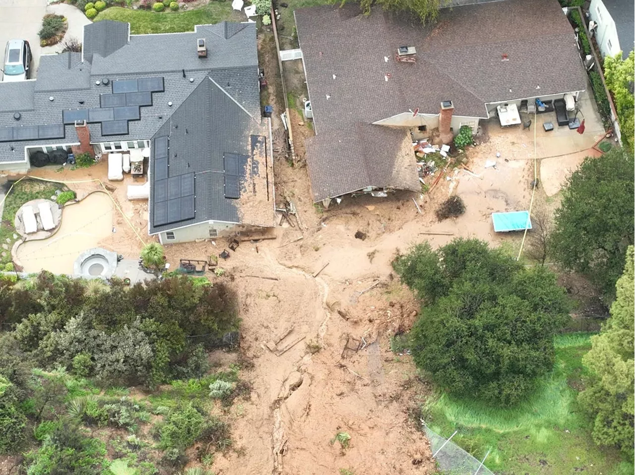 USGS Invests $1 Million to Mitigate Landslides Fueled by Climate ChangeThe U.S. Geological Survey (USGS) is allocating $1 million to a new initiative aimed at reducing the impact of landslides, which cause an estimated $1 billion in annual economic damage and are becoming more frequent due to climate change. The funding will support local, state, tribal, and territorial government projects focused on mitigating landslide risks. Landslides, triggered by various factors including earthquakes, storms, and wildfires, pose a significant threat, claiming the lives of 25 to 50 people annually in the U.S. The USGS emphasizes that climate change intensifies rainfall, increasing the likelihood of landslides. Additionally, recently burned areas are more susceptible to landslides due to altered soil and vegetation.
Read more »
 ZTE Nubia Music 2: A Budget-Friendly Smartphone Focused on AudioThe ZTE Nubia Music 2 is a budget-friendly smartphone emphasizing audio quality. It features a 2.1-channel audio system with three full-range speakers, DTS:X Ultra support, and a 3.5mm audio jack. While it boasts impressive audio capabilities, the phone uses a low-performance Unisoc T7200 chipset and a 50-megapixel main camera.
Read more »
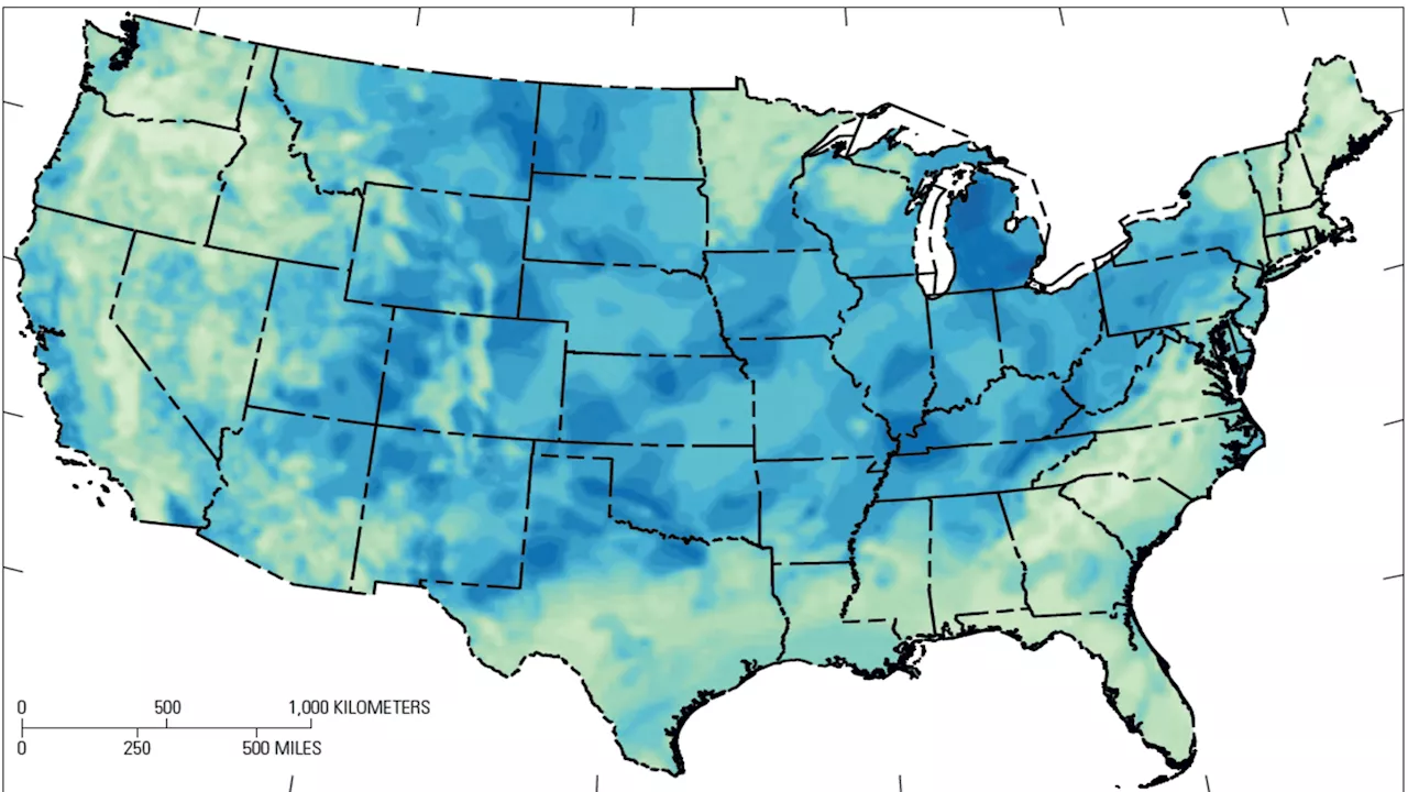 USGS Map Reveals Potential for Vast US Hydrogen ReservesA new map published by the US Geological Survey (USGS) challenges conventional beliefs about the availability of naturally occurring hydrogen, indicating that several US states could hold significant reserves of this potential clean energy source. This discovery comes as governments worldwide seek alternatives to fossil fuels, with the USGS estimating that just 2% of untapped hydrogen reserves could provide carbon-free fuel for the world for 200 years.
Read more »
 Planetary ScienceDid you know the USGS also helps to explore the solar system? USGS scientists research other planetary bodies, and work with NASA to support planetary exploration throughout the solar system. Learn more about planetary science at the USGS below!
Read more »
 USGS Celebrates the Year of Open ScienceThroughout the Year of Open Science, USGS will be sharing open science success stories, tips and tools for robust open science practices, and discussions on the value of open, equitable, and secure scientific enterprises.
Read more »