
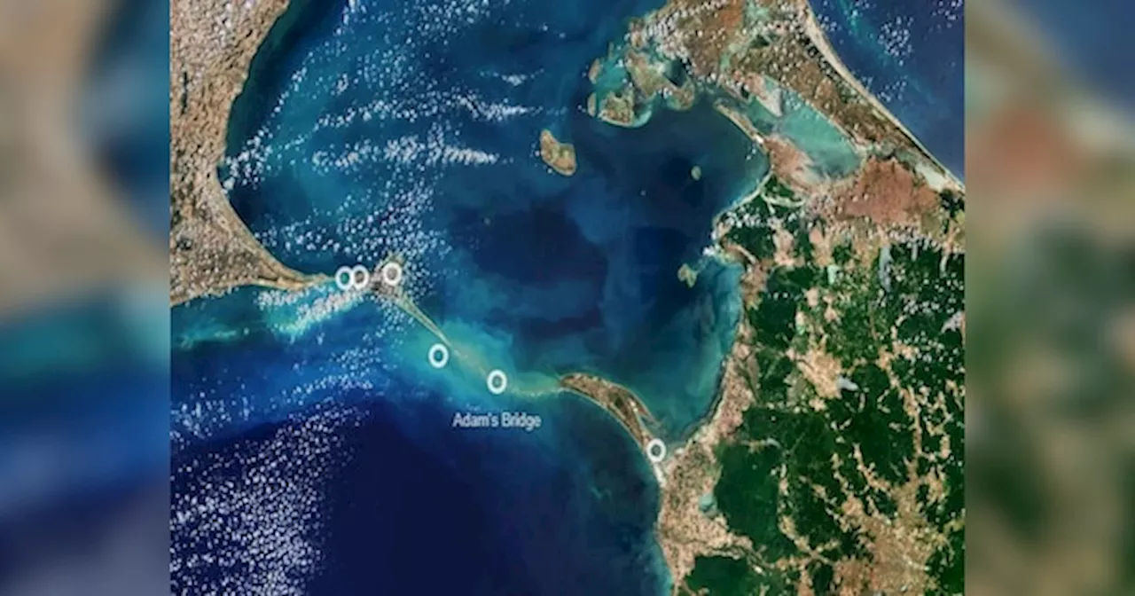
Indian scientists have created the most detailed map of Ram Setu (Adam’s Bridge) using data from an American satellite. This map is as large as a train carriage and it shows that the 29-kilometer long Ram Setu is 8 meters above sea level.
Indian scientists have created a detailed map of Ram Setu with the help of data from an American satellite. The data reveals that 99.98% of the 29-kilometer-long bridge is submerged under shallow water.
Indian scientists have created the most detailed map of Ram Setu using data from an American satellite. This map is as large as a train carriage and it shows that the 29-kilometer long Ram Setu is 8 meters above sea level. The map was created by ISRO scientists and published in Scientific Reports. Ram Setu, or Adam’s Bridge, connects India’s Rameswaram Island to Sri Lanka’s Mannar Island. It is a chain of limestone shoals, mostly underwater, with no rocks or vegetation. According to the epic Ramayana, this bridge was built by Lord Rama’s monkey army to reach Lanka. राजनीति : रामसेतु के साक्षात 'सबूत'... NASA के सैटलाइट से मिलीं तस्वीरें, ZEE NEWS ने 2015 में रिपोर्ट दिखाईISRO’s Jodhpur and Hyderabad centers used NASA's ICESat-2 satellite, which has a laser altimeter to measure underwater structures. Data from October 2018 to October 2023 helped scientists create a detailed 10-meter resolution map of the submerged ridge.Most of Ram Setu is under shallow water, making it hard to survey by ships. Scientists found 11 narrow channels under the bridge, 2-3 meters deep, that help water flow between the Gulf of Mannar and the Palk Strait.The research confirms that Adam’s Bridge is an underwater extension of Dhanushkodi and Talaimannar Island. It has a varying depth, with a 1.5-kilometer stretch in extremely shallow water.The total volume of Adam’s Bridge is about 1 km³, but only 0.02% of it is above sea level. This matches satellite imagery showing that most of the bridge is submerged.Geological evidence shows India and Sri Lanka were once part of the ancient Gondwana supercontinent, which moved north and joined the Laurasian continent 35-55 million years ago. Tectonic activity and sea level changes likely formed the land bridge.
Adam Bridge Ram Setu History Ram Setu Adam Bridge Ram Setu History
United States Latest News, United States Headlines
Similar News:You can also read news stories similar to this one that we have collected from other news sources.
 अयोध्या आ रहा देश का सबसे बड़ा धनुष: लंबाई इतनी कि हाईवे के तारों में फंसा, कंपनी अफसरों को बुलाया; 4 हजार क...Rajasthan Sumerpur Shreeji Sanatan Seva Sansthan Ram Dhanush Baan Hanuman Gada. Follow Ayodhya Ram Mandir Latest News and Updates On Dainik Bhaskar (दैनिक भास्कर)
Read more »
 NTA : পরীক্ষাপদ্ধতি হবে আরও সুরক্ষিত, এনটিএ-র সংস্কারে কমিটি গড়ল কেন্দ্র, শীর্ষে ইসরোর প্রাক্তন প্রধানFormer ISRO chief to lead the panel for reforming National Testing Agency
Read more »
 ESA ने शेयर की Ram Setu की अद्भुत तस्वीरें, बस देखते रह गए दुनियाभर के लोगAdam’s Bridge India and Sri Lanka: अंतरिक्ष से भारत को श्रीलंका से जोड़ने वाले राम सेतु (Ram Setu) की नई तस्वीरें सामने आई है. इन तस्वीरों को यूरोपीय अंतरिक्ष एजेंसी (ESA) ने साझा किया है.
Read more »
 Union Minister Smells ‘Conspiracy’ In Bihar Bridge Collapse, Says After Lok Sabha Polls...Union Minister Jitan Ram Manjhi has responded to the bridge collapsing issue in Bihar by raising the possibility of a conspiracy behind the incidents.
Read more »
 अग्निपथ योजना पर नेता विपक्ष और रक्षा मंत्री में से किसका दावा सच ?Agniveer Scheme Pension, Martyr Status, 1 crore compensation, truth behind Rahul Gandhi and Rajnath Singh Claims | अग्निपथ योजना पर राहुल और राजनाथ सिंह में से किसका दावा सच ?
Read more »
 ट्रेन के डिब्बे जितने बड़े मैप से खुला राम सेतु का रहस्य, 99.98% पानी में डूबा है 8 मीटर ऊंचा पुलRam Setu Adams Bridge Map: भारतीय अंतरिक्ष अनुसंधान संगठन (ISRO) ने राम सेतु का सबसे विस्तृत नक्शा तैयार किया है. इस प्राचीन पुल को एडम्स ब्रिज के नाम से भी जाना जाता है.
Read more »