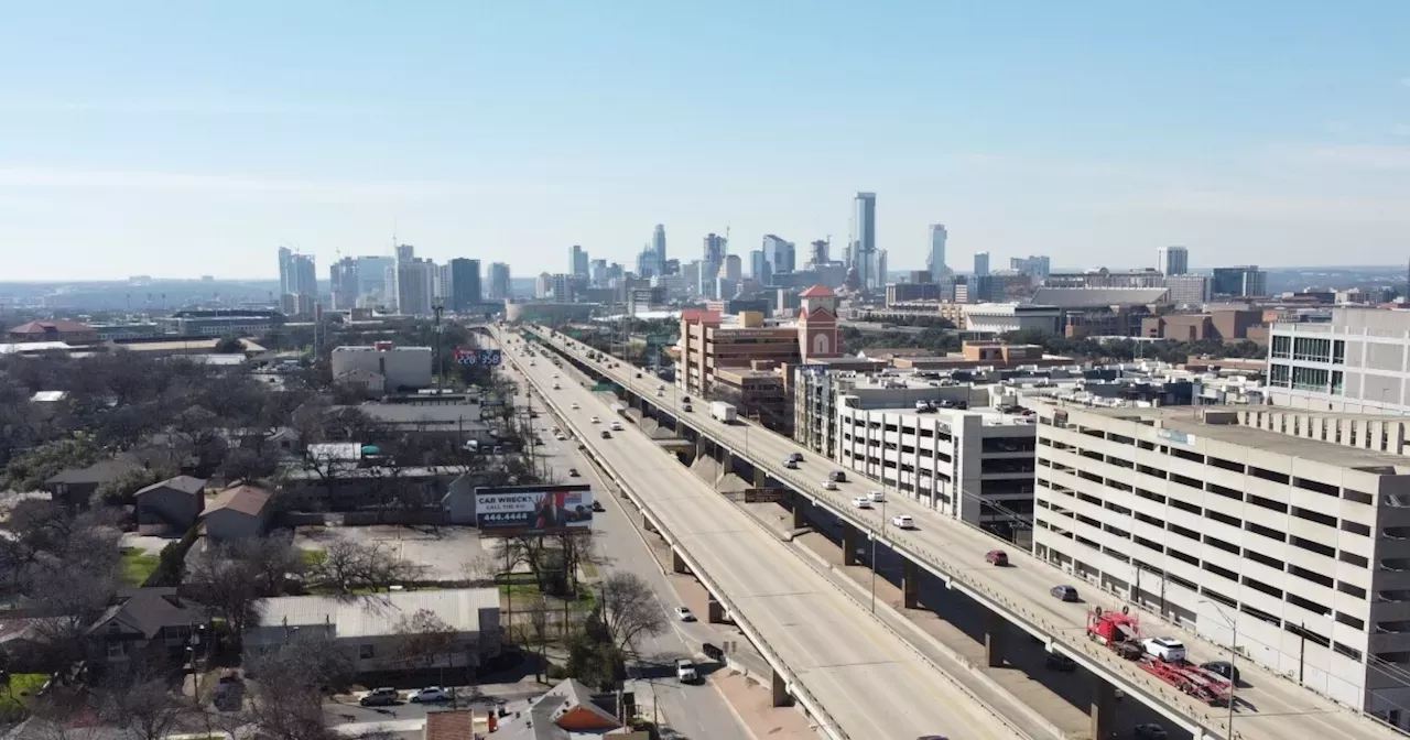
An in-depth walkthrough of what TxDOT plans to do along I-35 from Ben White Boulevard to U.S. 290 East.
Construction is scheduled to start this summer on the biggest expansion of I-35 in Austin's history. The project includes tearing down the upper decks, rebuilding east-west bridges and adding at least four lanes in each direction along an 8-mile stretch of highway from U.S. 290 East to Ben White Boulevard.
Say goodbye to the upper decks. These elevated lanes opened in 1975. They'll be torn down and the highway will be widened into neighboring properties. Freeway lanes along the entire I-35 CapEx Central project would narrow. Main lanes would be 11-feet wide instead of their current width of 12 feet. Managed lanes would also be 11-feet wide.of highways in Dallas, San Antonio and Houston found people drove about 2 miles per hour slower in 11-foot-wide lanes than 12-foot-wide lanes. But narrower lanes tended to result in more crashes causing injury or death, the study found.
The blue lines represent sidewalks. Some of the sidewalks on the southbound frontage road south of Woodward Street have been labeled"From Oltorf Street to Woodward Street, the pavement of the I-35 main lanes would be upgraded from asphalt to concrete. Concrete is more expensive than asphalt, but it's more resistant to weather, supports heavier loads without grooves forming in the pavement and absorbs less heat.
But even after the Oltorf Street bridge upgrade in 2020, people on foot still have to cross"slip lanes" without any traffic signal. Slip lanes are those right-turn lanes that let drivers quickly bypass the normal intersection to turn right. They're convenient for drivers but can be dangerous for pedestrians.
The general purpose lanes would be lowered here. The managed lanes would be at about the same level as the frontage roads.A cross-section of I-35 near Woodland Avenue shows the new configuration, with lowered general purpose lanes and the managed lanes running at about the same level as the frontage roads.
Austin City Council considered but rejected a plan to spend at least $15 million on a 300-foot-wide bridge at Woodland. TxDOT will pay for the 75-foot-wide pedestrian bridge and says it might look something like this.An illustration of what the 75-foot-wide pedestrian bridge over I-35 at Woodland Avenue could look like.
TxDOT says pedestrians will have to cross underneath Riverside Drive. An apparent tunnel or walkway underneath Riverside is partially visible in this bare-bones rendering of the interchange.Sidewalks crossing Riverside Drive would go under the street. TxDOT is planning to build the Riverside Drive interchange with space for Austin's planned light-rail line. Construction on the light-rail system won't start till 2027 at the earliest.
The change means the Ann and Roy Butler Hike and Bike Trail will be detoured for at least six years to East Avenue, which runs under I-35.A long-term trail detour will be in effect as TxDOT uses the construction staging area on Waller Beach for at least six years. Under the latest version of the plans, which TxDOT has been working on with the city, there could be a smaller cap — known as a"stitch" — next to Holly Street. The stitch would add an acre of space on top of the highway. This area, shaded in blue below, would again be at the city's expense.
TxDOT has created some renderings of what the highway could look like after it's lowered and covered. Here's a conceptual illustration of Cesar Chavez.The City of Austin hasn't decided if it can pay for the caps over I-35, let alone what to put on them. This conceptual illustration shows what a park might look like if the city ponies up hundreds of millions of dollars to cover the newly trenched highway.
After 15th Street, the frontage roads would pass over the highway together and run next to each other on the east side of I-35 until Dean Keeton Street. Here's an overhead of what that would look like south of Martin Luther King Jr. Boulevard.Northbound and southbound frontage roads would cross together over I-35 north of 15th Street and land just south of Martin Luther King Jr Boulevard.
By Dean Keeton, the main lanes of I-35 would run directly under the frontage roads, as you can see in this cross-section.A technical drawing showing a cross-section of I-35 at Dean Keeton. The frontage road lanes, running side-by-side, would be directly above the northbound main lanes of I-35. The northern-most cap in the I-35 CapEx Central project would stretch from 38 1/2 Street almost to Airport Boulevard.
United States Latest News, United States Headlines
Similar News:You can also read news stories similar to this one that we have collected from other news sources.
 TxDOT seeks public input for enhancing Austin-San Antonio linkage: open houses announcedAUSTIN, Texas (KEYE) -- The Texas Department of Transportation is asking for the public’s input when it comes to ways of better linking Austin to San Antonio.Tx
Read more »
 The Austin Chronic: How Worried Should Cannabis Users Be Over Paxton Suing Austin?A Q&A with Congressman Greg Casar
Read more »
 2023 Fish Fry Guide: List of weekly Lenten dinners in Central OhioHere’s where to get your fish fry and Lenten dinner in Central Ohio!
Read more »
 Austin airport sees record number of travelers in 2023More than 22 million travelers passed through ABIA last year, beating the record set just the year before by a million passengers. Here's what some travelers had to say about their airport experience and the city's plan on increasing capacity.
Read more »
 Austin FC Eats: Empanadas, Pulled Pork, Popsicles Headline New Concession OptionsPlus: an update on McKalla Station
Read more »
 Austin ISD completes all special education evaluations that were overdue from the last school yearThe completion of nearly 1,200 evaluations is an important milestone in the district's effort to improve services for students with disabilities.
Read more »