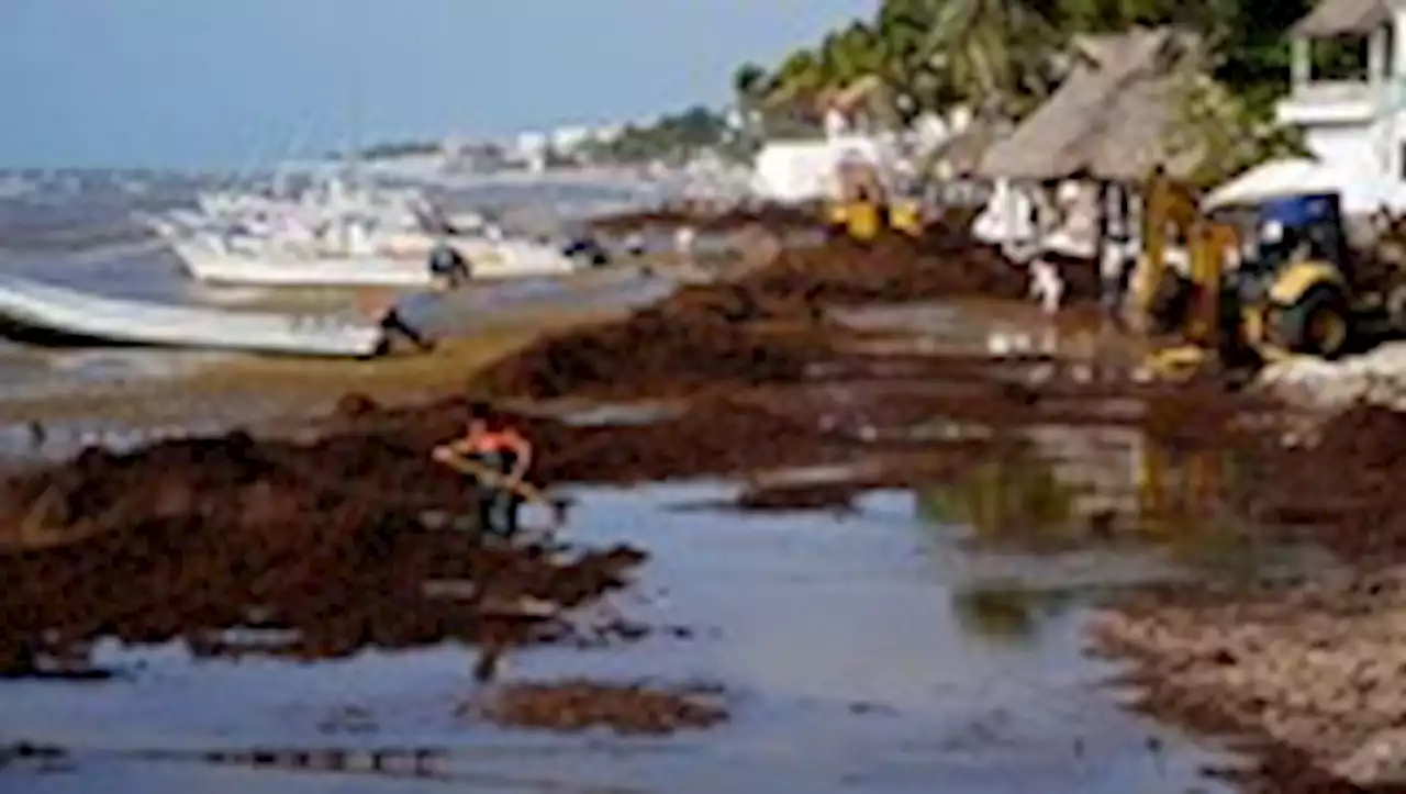
Masses of tangled brown seaweed, collectively weighing about 13 million tons, that typically float in the Atlantic Ocean are once again drifting toward shore, where they could pose a significant threat to coastal environments and beach communities.
Masses of tangled brown seaweed that typically spend most of the year floating around in the open waters of the Atlantic Ocean are once again drifting toward shore, where they couldKnown as the great Atlantic Sargassum belt, the seaweed clusters collectively weigh about 13 million tons, according to most recent calculations — and are large enough to be seen from space.
“The projection that we have for this year is that it’s going to be at least as big, if not a little bit bigger, than last year’s bloom,” said Barnes, who’s been tracking the belt’s size and path. “But last year was pretty bad already.”Sargassum is athat’s abundant in the ocean. Its ability to float comes from the small berrylike orbs sprouting from the plant — gas-filled structures mostly containing oxygen.
The great Atlantic Sargassum belt refers to a formation of the floating seaweed that typically extends from the west coast of Africa toward Brazil and around the Caribbean region, said Brian Lapointe, a research professor at Florida Atlantic University who has studied sargassum for more than 40 years. Lapointe estimates that the belt is about 5,000 miles long and 300 miles wide.Experts emphasize that it is not a single, giant blob, but rather a collection of blobs.
The patches can vary widely in size, Lapointe said. Some clumps might be the size of a basketball while others can extend for hundreds of meters or even miles, depending on ocean conditions.Recent satellite images show patches just south of islands in the northern Caribbean and offshore of the eastern Yucatán Peninsula, Barnes said.
United States Latest News, United States Headlines
Similar News:You can also read news stories similar to this one that we have collected from other news sources.
 NIL: The gulf between blue-chip universities and HBCUsStudent-athletes are earning far more than they did in the first year of the name-image-likeness (NIL) regime, per industry interviews and public records obtained by Axios.
Read more »
 Kelsey's in Atlantic City offers soul food at the shoreThe menu is soul food classics with an emphasis on seafood, and live music acts are on the scene most nights.
Read more »
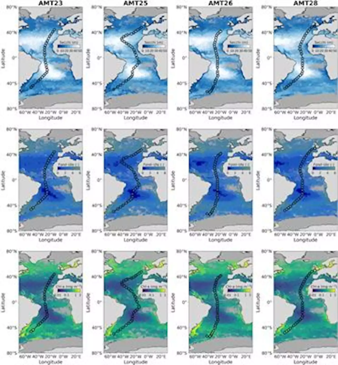 Frontiers | Evaluating historic and modern optical techniques for monitoring phytoplankton biomass in the Atlantic OceanTraditional measurements of the Secchi depth (zSD) and Forel-Ule colour were collected alongside modern radiometric measurements of ocean clarity and colour, and in-situ measurements of chlorophyll-a concentration (Chl-a), on four Atlantic Meridional Transect (AMT) cruises. The data were used to evaluate historic and modern optical techniques used for monitoring Chl-a, and to evaluate remote-sensing algorithms. Comparisons between historic and modern optical measurements were broadly consistent with current understanding, with Secchi depth inversely related to Forel-Ule colour and to beam and diffuse attenuation, positively related to the ratio of blue to green remote-sensing reflectance and euphotic depth. The relationship between Secchi depth and Forel-Ule on AMT was found to be in closer agreement to historical relationships when using data of the Forel-Ule colour of infinite depth, rather than the Forel-Ule colour of the water above the Secchi disk at half zSD. Over the range of 0.03-2.95 mg m-3, Chl-a was tightly correlated with these optical variables, with the ratio of blue to green remote-sensing reflectance explaining the highest amount of variance in Chl-a (89 %), followed by the Secchi depth (85 %) and Forel-Ule colour (71-81 %, depending on the scale used). Existing algorithms that predict Chl-a from these variables were evaluated, and found to perform well, albeit with some systematic differences. Remote sensing algorithms of Secchi depth were in good agreement with in-situ data over the range of values collected (8.5 - 51.8 m, r2 | 0.77, unbiased root mean square differences around 4.5 m), but with a slight positive bias (2.0 - 5.4 m). Remote sensing algorithms of Forel-Ule agreed well with Forel-Ule colour data of infinite water (r2 | 0.68, mean differences |1). We investigated the impact of environmental conditions and found wind speed to impact the estimation of zSD, and propose a path forward to include the effect of wind in current Secchi depth th
Read more »