
The USGS Volcano Hazards Program enhances public safety and minimize social and economic disruption from volcanic unrest and eruption. We accomplish this by delivering effective forecasts, warnings, and information about volcano hazards based on scientific understanding of volcanic processes. Learn more by exploring USGS volcanic maps.
USGS provides unbiased, objective, and impartial scientific information upon which our audiences, including resource managers, planners, and other entities, rely.The USGS Volcano Hazards Program enhances public safety and minimize social and economic disruption from volcanic unrest and eruption.
We accomplish this by delivering effective forecasts, warnings, and information about volcano hazards based on scientific understanding of volcanic processes. Learn more by exploring USGS volcanic maps. January 2, 2025—Kīlauea summit eruption reference mapDecember 30, 2024 — Thermal map of eruption at Kīlauea summit This thermal map shows eruptive activity on December 30, 2024, within Halemaʻumaʻu crater at the summit of Kīlauea. Lava fountaining and flows were active in the southwest portion of the caldera. Cooler colors show lower temperatures while hotter colors show higher temperatures.This thermal map shows lava flows covering the floor of Halemaʻumaʻu crater at the summit of Kīlauea. Fountaining was active in the southwest portion of the caldera, with flows extending east onto the downdropped block. Cooler colors show lower temperatures while hotter colors show higher temperatures.This reference map depicts the new Kīlauea summit eruption within Halema‘uma‘u crater on December 23, 2024, constructed using data captured during a USGS Hawaiian Volcano Observatory helicopter overflight at 9:30 a.m.October 4, 2024 — Reference map of September 2024 Kīlauea middle East Rift Zone eruption This reference map depicts the final state of the Kīlauea middle East Rift Zone eruption that occurred between September 15 and 20, 2024.This map shows recent deformation at Kīlauea over the timeframe of September 14–26, 2024, during which an eruption occurred on the East Rift Zone.A helicopter overflight on September 20, 2024, allowed for aerial visual and thermal imagery to be collected at the middle East Rift Zone eruption site on Kīlauea.September 19, 2024 — Thermal map of eruption on Kīlauea East Rift Zone A helicopter overflight on September 19, 2024, allowed for aerial visual and thermal imagery to be collected at the middle East Rift Zone eruption site on Kīlauea.
United States Latest News, United States Headlines
Similar News:You can also read news stories similar to this one that we have collected from other news sources.
 Kilauea volcano eruption paused after spewing lava in Hawaii, USGS saysThe eruption occurred about 2:20 a.m. local time Monday within Halemaʻumaʻu crater inside Kilauea's summit caldera, a closed area of Hawaii Volcanoes National Park.
Read more »
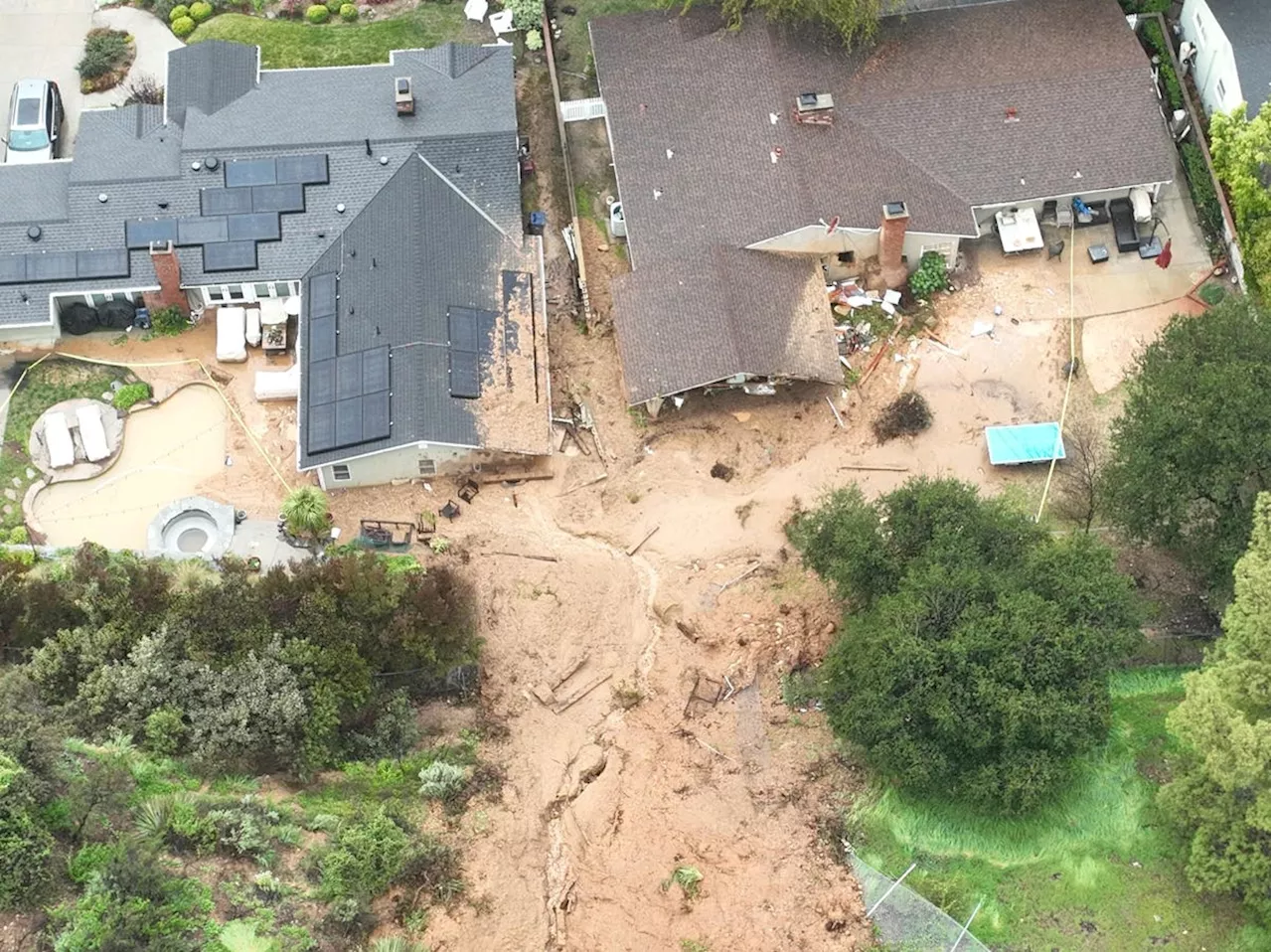 USGS Invests $1 Million to Mitigate Landslides Fueled by Climate ChangeThe U.S. Geological Survey (USGS) is allocating $1 million to a new initiative aimed at reducing the impact of landslides, which cause an estimated $1 billion in annual economic damage and are becoming more frequent due to climate change. The funding will support local, state, tribal, and territorial government projects focused on mitigating landslide risks. Landslides, triggered by various factors including earthquakes, storms, and wildfires, pose a significant threat, claiming the lives of 25 to 50 people annually in the U.S. The USGS emphasizes that climate change intensifies rainfall, increasing the likelihood of landslides. Additionally, recently burned areas are more susceptible to landslides due to altered soil and vegetation.
Read more »
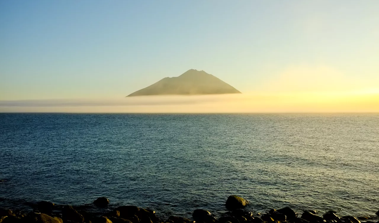 1831 Volcanic Eruption Mystery Solved, Kuril Islands Identified as SourceA 200-year-old volcanic eruption mystery has been solved, pinpointing the Kuril Islands as the source of a massive event that caused global famines and crop failures. Scientists used advanced technology to analyze ash shards from polar ice cores, confirming the impact of a volcano on the remote chain of islands between Russia and Japan.
Read more »
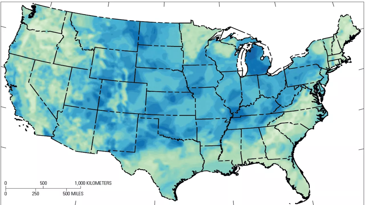 USGS Map Reveals Potential for Vast US Hydrogen ReservesA new map published by the US Geological Survey (USGS) challenges conventional beliefs about the availability of naturally occurring hydrogen, indicating that several US states could hold significant reserves of this potential clean energy source. This discovery comes as governments worldwide seek alternatives to fossil fuels, with the USGS estimating that just 2% of untapped hydrogen reserves could provide carbon-free fuel for the world for 200 years.
Read more »
 Apple Maps Is Actually Pretty Good NowAfter years of refinement, Apple Maps has become a reliable alternative to Google Maps. The article highlights several areas where Apple Maps excels, including clearer turn-by-turn directions, a convenient 'Nearby transit' feature, seamless integration with Apple's ecosystem, and a cleaner user interface. While Google Maps still boasts a larger database of businesses, Apple Maps is surprisingly competent and worth trying.
Read more »
 USGS Celebrates the Year of Open ScienceThroughout the Year of Open Science, USGS will be sharing open science success stories, tips and tools for robust open science practices, and discussions on the value of open, equitable, and secure scientific enterprises.
Read more »