Wintry precipitation possible Tuesday
Read full article: Tracking an artic blast of cold air in Houston drastically dropping temperatures on Sunday.
Here's how to get fabulous items to make life around the house easier, more organized and tidy — all while saving big.– Today will be sunny with mostly clear skies this evening with our highs - just above average in the 60s. We’ll continue to track another arctic blast arrives this afternoon dropping our highs from the 60s to the 40s by tomorrow morning.We’ll continue to track this cold front that again - arrives today with artic cold air headed our way the next couple of days after today.
This year we will be dealing with pretty strong breezy coming from the north at 15 mph. This will be a stout headwind for half marathoners between miles 9-11. This will cause a headwind for full-marathon runners between miles 11 and 12 and also for miles 13-18.Snow possible late Monday to Tuesday morning:
Through the weekend the Stormtracker 2 Weather Team will track changes as they come in and pass them along on all our platforms.These scenarios WILL change over the next few days so any discussion about who will see snow/sleet/freezing rain is futile at this point. But, the likelihood of seeing some type of wintry scenario is becoming more likely.
Houston Weather Weather Updates
United States Latest News, United States Headlines
Similar News:You can also read news stories similar to this one that we have collected from other news sources.
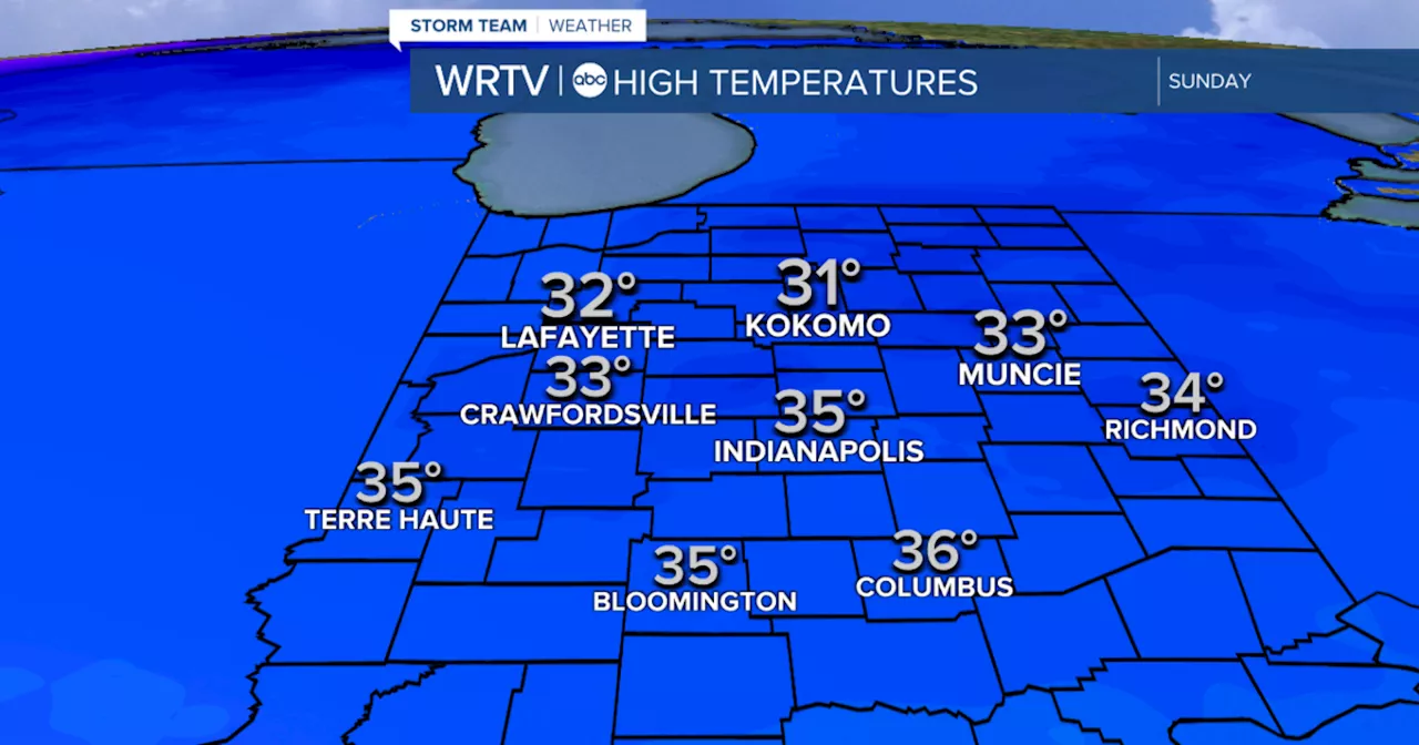 Warmer Sunday with a light wintry mix possibleYour WRTV Storm Team forecast for Central Indiana: Temperatures turn sharply colder again in the week ahead.
Read more »
![]() First Alert Weather Day: Tracking rain & strong storms Saturday into SundayRemaining warm through New Year’s Eve, with colder air moving back into Alabama by January.
First Alert Weather Day: Tracking rain & strong storms Saturday into SundayRemaining warm through New Year’s Eve, with colder air moving back into Alabama by January.
Read more »
 Houston’s 5 Best Weekend Food Bets: BBQ with Santa and an Oyster-Fueled Sunday FundayHere's a look at this weekend's tasty food and drink happenings: Brunch with Santa at Tavola Saturday, 11:30 to 2 p.m. 1800 Post Oak Tavola’s Santa Brunch will showcase its full brunch menu and a kids menu alongside exciting activities for the kiddos, including $38 gingerbread house kits, a Santa...
Read more »
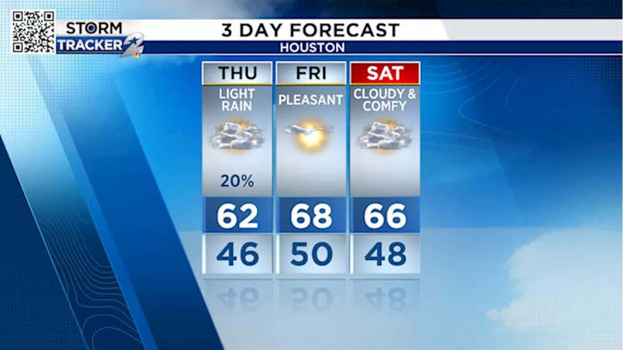 Houston Weather Forecast: Light Rain Today, Severe Threat Sunday, Snow Possible Next WeekExpect light rain showers today mainly south of I-10. Pleasant weather is predicted for Friday and Saturday. A severe weather threat is possible Sunday, mainly northeast of Houston. There's a chance of snow next week, particularly north of I-10.
Read more »
 Severe Weather Threat Sunday Afternoon for Houston AreaWhile not as intense as last week's tornado outbreak, Sunday's storms still carry a risk of damaging winds and frequent lightning strikes. The greatest threat is northeast of Houston, including Huntsville, Conroe, Livingston, and Liberty. The line of storms is expected to hit Houston from noon-4 p.m. and reach the coast from 3 p.m.-7 p.m.
Read more »
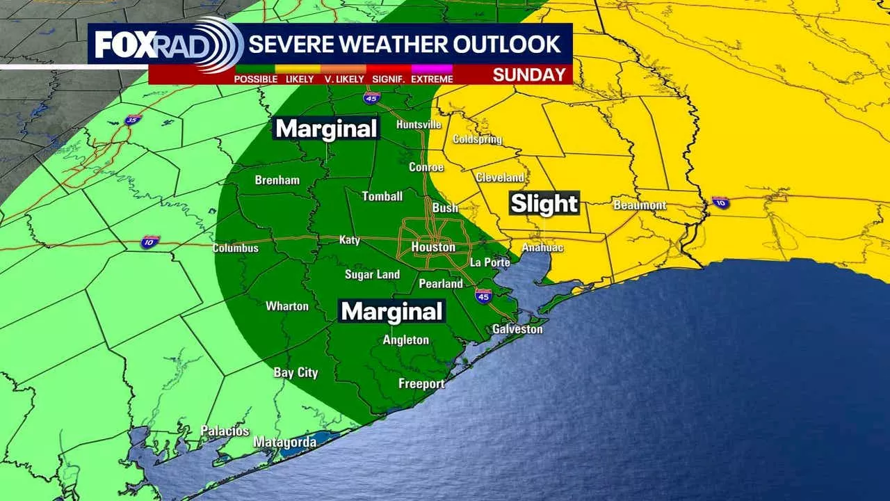 Severe Storms Expected Sunday in Houston, Followed by Arctic FreezeHouston residents are urged to prepare for severe weather on Sunday as storms with the potential for heavy rain, lightning, strong winds, and even isolated tornadoes are expected. The area will then experience a significant drop in temperatures with a powerful cold front bringing near-freezing conditions.
Read more »