
At 7:25 p.m. on Tuesday, the National Weather Service released a severe thunderstorm warning in effect until 8:15 p.m. for Bradford County.
Published: Apr. 29, 2025, 7:29 p.m.At 7:25 p.m. on Tuesday, the National Weather Service released a severe thunderstorm warning in effect until 8:15 p.m. for Bradford County."At 7:24 p.m., severe thunderstorms were located along a line extending from Caton to near Mansfield to Morris, moving east at 65 mph," says the weather service.
"Expect damage to roofs, siding, and trees." Locations impacted by the warning include Cherrytown, Sayre, Dunning, West Warren, Durell, Monroeton, Rome, Towanda, West Franklin and Orwell. The weather service comments, "For your protection move to an interior room on the lowest floor of a building."Each year, lightning strikes the United States approximately 25 million times, with the majority of these electrifying events occurring during the summer months. Unfortunately, lightning is responsible for claiming the lives of approximately 20 people annually, as reported by the weather service. The threat of lightning becomes more pronounced as thunderstorms draw nearer, peaking when the storm is directly overhead and gradually waning as it moves away.Lightning safety plan:Monitor the sky for threatening signs and listen for the sound of thunder. If thunder is audible, it's an indication that lightning is nearby.Once you've found shelter indoors, abstain from using corded phones, electrical appliances, or plumbing fixtures, and refrain from approaching windows and doors. Lightning can follow conductive pathways, and these precautions reduce the risk of electrical surges.After the last lightning strike or thunderclap, wait at least 30 minutes before resuming outdoor activities.When indoor shelter isn't available: If you find yourself outdoors without access to indoor shelter during a thunderstorm, take these steps to maximize your safety:Steer clear of tall, isolated trees and other prominent objects. In wooded areas, stay close to lower stands of trees. If you're with a group, ensure individuals are spread out to prevent lightning current from transferring between people. Camping in an open setting during a thunderstorm is strongly discouraged. If no alternative exists, set up camp in a valley, ravine, or other low-lying areas. Remember that a tent offers no protection against lightning. Do not approach water bodies, wet objects, or metal items. While water and metal don't attract lightning, they conduct electricity effectively and can pose significant risks. In summary, when facing the threat of lightning, preparedness and vigilance are your best allies. By following these guidelines, you can significantly reduce the likelihood of lightning-related incidents and prioritize your safety.Heavy rainfall may lead to flooding if prolonged or if there is excessive runoff. Excessive runoff can be a result of saturated ground and/or rainfall intensity. Follow these recommendations from the weather service to stay safe in heavy rain:During heavy rain, avoid parking or walking near culverts or drainage ditches, where swift-moving water can pose a serious risk.Use the two-second rule to maintain a safe distance from the car in front of you and allow an extra two seconds in heavy rain.On wet roads, slowing down is paramount. Gradually ease off the accelerator and avoid abrupt braking to prevent skidding.Stick to the middle lanes on multi-lane roads to minimize the risk of hydroplaning, as water tends to accumulate in outer lanes.Enhance your visibility in heavy rain by activating your headlights. Be particularly vigilant for vehicles in blind spots, as rain-smeared windows can obscure them.The first half-hour of rain is when roads are slickest due to a mix of rain, grime, and oil. Exercise heightened caution during this period.Large trucks and buses can reduce your visibility with tire spray. Avoid tailgating and pass them swiftly and safely.Overloaded wiper blades can hinder visibility. If rain severely impairs your vision, pull over and wait for conditions to improve. Seek refuge at rest areas or sheltered spots. If the roadside is your only option, pull off as far as possible, preferably past the end of a guard rail, and wait until the storm passes. Keep your headlights on and turn on emergency flashers to alert other drivers of your position. In the face of heavy rain, these precautions can make a significant difference in ensuring your safety on the road. Remember to stay informed about weather conditions and heed guidance from local authorities for a secure journey. Advance Local Weather Alerts is a service provided by United Robots, which uses machine learning to compile the latest data from the National Weather Service. If you purchase a product or register for an account through a link on our site, we may receive compensation.
Weather Alerts @Topstories @Exalerts
United States Latest News, United States Headlines
Similar News:You can also read news stories similar to this one that we have collected from other news sources.
 Update: Thunderstorms with damaging winds and penny-sized hail in Bradford County TuesdayOn Tuesday at 2:08 p.m. the National Weather Service issued an updated severe thunderstorm warning in effect until 2:30 p.m. for Bradford County.
Read more »
 Update: Thunderstorms with quarter-sized hail and damaging winds in Greene County SaturdayOn Saturday at 7:39 p.m. an updated severe thunderstorm warning was issued by the National Weather Service in effect until 8:45 p.m. for Greene County.
Read more »
 Severe thunderstorm watch issued for Bradford County until Tuesday nightA severe thunderstorm watch was issued by the National Weather Service on Tuesday at 3:28 p.m. in effect until 10 p.m. for Bradford County.
Read more »
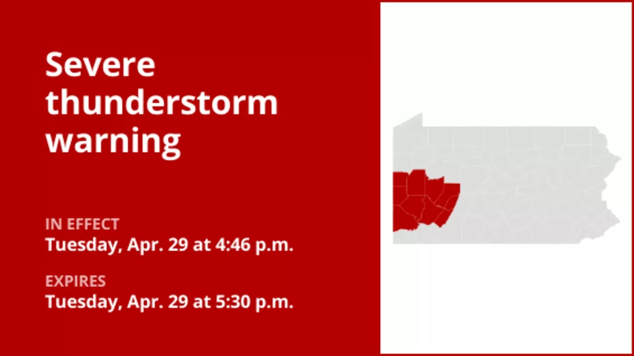 Update: Thunderstorms with damaging winds in Southwest Pa. TuesdayOn Tuesday at 4:46 p.m. an updated severe thunderstorm warning was issued by the National Weather Service in effect until 5:30 p.m. for Allegheny, Armstrong, Beaver, Butler, Indiana, Lawrence, Washington and Westmoreland counties.
Read more »
 Thunderstorms with damaging winds in Somerset County Tuesday – gusts could peak at 60 mphAt 5:54 p.m. on Tuesday, the National Weather Service released a severe thunderstorm warning in effect until 6:30 p.m. for Somerset County.
Read more »
 Update: Damaging winds forecast with thunderstorms in Greene County TuesdayAt 6:30 p.m. on Tuesday, the National Weather Service released an updated severe thunderstorm warning in effect until 7:15 p.m. for Greene County.
Read more »