
Scattered showers, isolated thundershowers are possible overnight with strong winds. Saturday is an impact day as winds could peak between 45-50 miles per hour, possibly leading to power outages, downed branches.
A strong storm system slowly moving across southern Ontario & Quebec will control our weather most of this weekend with passing showers tonight and strong winds through Saturday . Showers and thundershowers are possible late Sunday . Light rain and showers are possible tonight, as an upper -level low associated with the storm in southern Canada moves overhead. Winds will be gusty, near 40 mph. Isolated thunder and lightning are possible.
As low pressure departs, and high pressure builds across the Ohio Valley Saturday, sustained northwesterly winds will increase to 20-30 mph, with gusts to 45 mph. Ridgetops could see gusts around 50 miles per hour. Isolated power outages are possible, and some tree limbs may come down. We'll see clouds to start, then clearing skies by evening. Highs will reach 60 degrees, and winds diminish late.Sunday will feature partly sunny skies, light winds, and warmer highs in the low 70s.
Carlisle Cumberland Dauphin Forecast Friday Harrisburg Impact Day Juniata Lancaster Lebanon Mifflin News 8 Perry Rain Saturday Showers Spring Storm Team Strong Winds Sunday WGAL Weather Weekend Windy
United States Latest News, United States Headlines
Similar News:You can also read news stories similar to this one that we have collected from other news sources.
 Clouds, Isolated Showers & Fog Tonight, Few Showers East ThursdayRain slowly tapers to isolated showers after sunset, but it stays mild and damp which could lead to some fog developing with pockets of drizzle overnight. Drier air moves into the region Thursday, but a few morning showers are possible in areas southeast of Harrisburg.
Read more »
 PM Update: A few showers tonight, remaining windy through SaturdayIt will be on the cool side to start the weekend. On Sunday, temperatures should rise well into the 70s.
Read more »
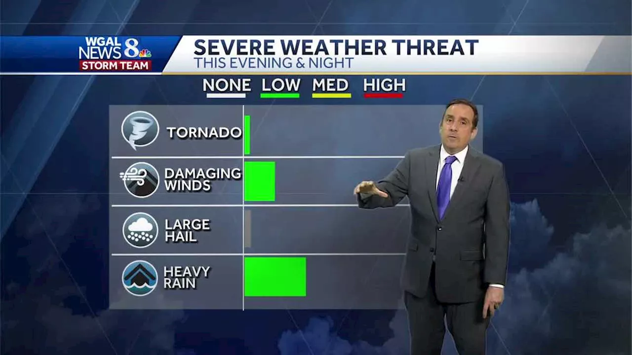 Impact: Strong Winds & Few Strong Storms, Heavy Rain TonightWinds may gust greater than 40 miles per hour tonight as periods of heavy rain cross the Valley. There may be isolated, embedded strong to severe thunderstorms as well.
Read more »
 Gusty Winds and Showers Expected TonightTemperatures rose to and past 70 in most spots this afternoon as gusty south winds pump moisture into the area ahead of a cold front. That advancing front will produce numerous showers and storms into tonight, some of which could be strong or even severe, with a quite small chance of damaging gusts or a brief tornado. Comparatively nicer tomorrow, but still a bit unsettled with the jet stream parked overhead. Scattered showers are around for the rest of the afternoon and into the evening. They will mostly pass quickly, but some might drop quick downpours. Odds of rain are at their highest and most widespread later this evening through an hour or two after midnight. A smaller window in there, perhaps from 9 p.m. to midnight, might see strong or severe storms, although the lack of heating and fuel at night should generally limit their intensity. After that, expect a couple more showers into dawn, with lows in the mid-50s to around 60
Read more »
 Scattered Showers Continue with Strong WindsScattered showers continue this evening as the strong upper-level low attached to the storm system that brought the heavy rain Monday through Wednesday moves over the Mid-Atlantic. Temperatures hover in the mid 40s with a stiff breeze from the northwest. Isolated showers are possible through the night as the winds increase. Steady strong winds from the northwest between 10 and 20 mph are possible as temperatures fall to the upper 30s. Feels like temperatures will be closer to freezing early Friday morning. Showers pick back up again in number and intensity Friday afternoon with highs close to 50. There could be some flakes trying to mix in with the rain at times at elevation for areas west and northwest of Harrisburg. No accumulation is expected where there could be some snow mixing in with the rain at times. Isolated showers are possible Saturday as the upper-level storm moves off the East Coast. Temperatures peak in the lower 50s
Read more »
 PM Update: Showers or storm possible through evening; patchy fog tonightBest odds for a rumble are over western parts of the area. Warm again on Wednesday.
Read more »