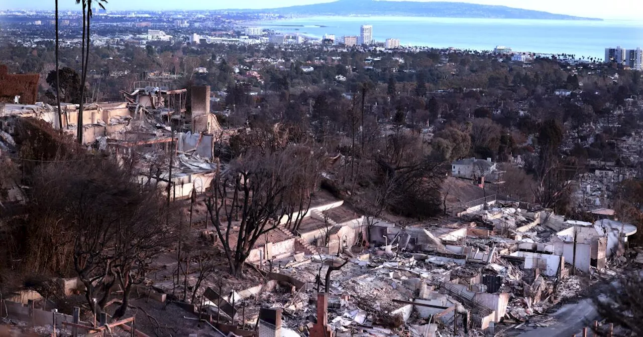
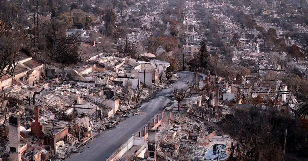
While the Palisades and Eaton fires continue to rage, fire containment has improved, allowing some residents to return to their devastated neighborhoods. Checkpoints remain in place in some areas, causing frustration for those trying to access their homes. Firefighters are working tirelessly to extinguish hot spots and prevent the fires from spreading, but the scars left behind are undeniable.
With fire containment improving and winds dying down, some residents are being allowed back into neighborhoods devastated by the Palisades and Eaton fires, though checkpoints still remained in other places. One day earlier, when evacuation orders in the neighborhood were lifted after more than a week, a line of cars stretched half a mile long north to Mulholland Drive, a California Highway Patrol officer said.
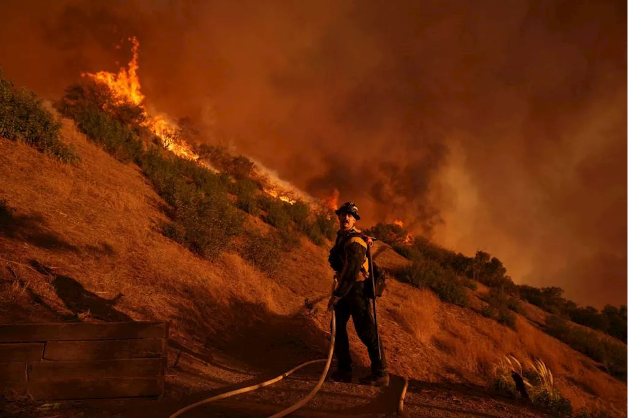
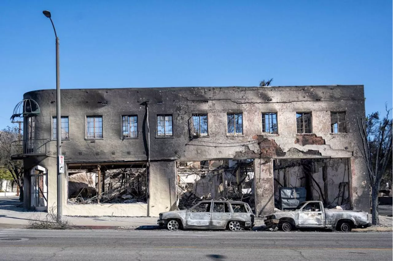
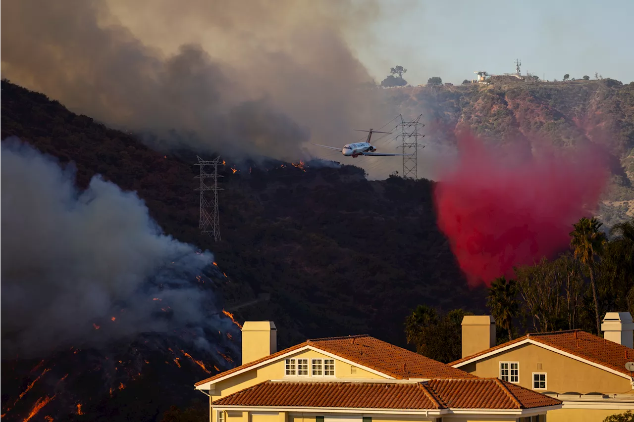
He estimated 2,000 cars had entered the checkpoint during his shift, with CHP and the National Guard carefully verifying proof of residency before allowing people to drive in. That meant that although Carl Rheuban, 75, returned home Thursday, his son’s partner, who doesn’t live with them, was a victim of bad timing as she was denied access. “Even as a passenger, they won’t let her up,” Rheuban said Friday morning before the checkpoint was removed. “I have another son who lives in Woodland Hills – they won’t let him in. He can’t come up to help me; we’ve got three freezers full of food that spoiled that I have to throw out.” Evacuated residents can now freely enter the northern part of the Topanga area from Topanga Canyon Boulevard at Cezanne Avenue, after officials late Friday morning removed the security checkpoint that had been set up there. Farther south on Topanga Canyon Boulevard, a checkpoint at Viewridge Road was still in place as of 1 p.m. Friday, with only residents who live south of the intersection permitted to enter. Los Angeles County officials say as many as 11,000 people will be able to return home as crews continue to get a handle on fires that started during an extreme wind event on Jan. 7. David Combs, 63, was one of the first residents to make it through the checkpoint Thursday. He ignored evacuation orders for the first two days after the Palisades fire broke out, remaining inside his home of 24 years at the Woodland Park Mobile Estates. But with no electricity and the fire raging, he left the complex on Jan. 9. “Hotels were gouging me, so I ended up sleeping in a big van that I have,” Combs, a construction project manager, said outside his three-bedroom home Friday. “It was rough.” He was desperate to get back home right away. When he evacuated, Combs had taken the ashes of his parents and put them in a storage unit for safekeeping, which he said tormented him. “It was the first thing I grabbed,” he said. “I didn't want to carry them around in case something happened. And it just broke my heart to think of my mom and dad in a storage unit.” The fires have destroyed more than 12,000 structures, including many homes, making them two of the most destructive — and deadliest — wildfires in California history. More than 8,600 firefighters from around the world are working the fires, with the focus over the next several days on constructing containment lines and extinguishing hot spots to prevent the fires from spreading. As the weather has begun to cooperate, firefighters have become more aggressive to get it under control before winds return next week. 'Every day we're getting aggressive. We know what's coming and the impact this fire has had on the community already,' said Colin Noyes, an information officer on the Palisades fire. In the first days of last week's fire storm, crews were on the defensive as extreme winds blew red-hot firebrand and embers across the landscape, starting fires faster than they could be put out. Firefighters were swarming into the region as the fire marched into neighborhoods and jackpots of dry, unburned brush in the foothills and rugged canyons. Over the weekend, crews established perimeters around both the Eaton and Palisades fires, corralling them in. Since then, firefighters have been turning the tide on the blazes bit by bit. 'We go 300 feet in from the perimeter and put out any hot spots, and any smokes we see,' Noyes said. Officials said on Friday they don't expect either fire to grow in acreage as they continue to attack the blaze where it flares up. Jim Hudson, an operations chief with the California Department of Forestry and Fire Protection on the Palisades fire, told community members Thursday night at Sinai Temple in Westwood that they've kept the fire from growing for several days and haven't seen it spread since Saturday. 'That is a testament to the hard work of the firefighters that have been on the line, working around the clock multiple shifts, and their dedication to all of you,' he told the audience. He said they expect containment to continue to grow in the coming days. In addition, they are using infrared aerial imaging to make sure “this thing is completely cooled off.” Despite the progress, some fire experts expressed remorse. Joe Everett, assistant Los Angeles Fire Chief and incident commander when Pacific Palisades burned, wished more could have been done quicker to spare the loss of thousands of homes and at least the deaths of 10 in the are
CALIFORNIA WILDFIRES PALISADES FIRE EATON FIRE FIRE Containment RESIDENT EVACUATIONS FIRE FIGHTERS WILDFIRE DAMAGE
United States Latest News, United States Headlines
Similar News:You can also read news stories similar to this one that we have collected from other news sources.
 Massive Palisades fire slows overnight; Eaton fire containment hits 27%But fire crews are bracing for the return of stronger winds, with a red flag warning lasting through Wednesday.
Read more »
 Eaton Fire Containment Improves, Palisades Fire Also Shows ProgressCrews battling the Eaton fire made significant progress overnight, achieving 45% containment. While winds caused some concern, they are expected to die down. The Palisades fire is also showing improvement, with 19% containment. The death toll from both fires has risen to 25.
Read more »
 Fire Containment Explained: Understanding the Percentage and Efforts to Limit WildfiresThis article explains the concept of fire containment in the context of wildfires. It clarifies that containment refers to establishing a perimeter around a fire to prevent its spread, rather than complete extinguishment. The article describes how fire crews use natural and human-made barriers, such as trenches and waterways, to create containment lines. It also provides examples of current wildfires in California and their containment percentages.
Read more »
 Live L.A. fire updates: Crews improve containment on Palisades, Eaton fires as winds die downHannah Fry covers breaking news for the Los Angeles Times.
Read more »
 Live L.A. fire updates: Crews improve containment on Palisades, Eaton fires as winds die downMatt Hamilton is a reporter for the Los Angeles Times.
Read more »
 Cal Fire's Fire Hazard Severity Zone Map Shows California Fire RiskCal Fire's new Fire Hazard Severity Zone map allows Californians to search for an address and see the location's probability of being affected by fire. The map assesses fire hazard, rather than risk, based on the physical conditions that create a likelihood of fire behavior over a 30 to 50-year period. The map considers terrain, local weather, and fire history over 50 years. Areas are ranked as moderate, high, or very high fire severity. The map is effective as of April 1, 2024 and focuses on areas under state responsibility, excluding federal land like the Sierra Nevada Mountains and some parts of the Bay Area.
Read more »