
Residents in areas recently scorched by wildfires are bracing for potential debris flows as cooler weather and rain are expected over the weekend. The National Weather Service predicts rain and mountain snow showers from Saturday afternoon through Monday, with the heaviest rainfall anticipated late Sunday into Monday. Thunderstorms may bring brief heavy downpours and small hail, primarily on Sunday and Monday. Authorities are taking precautions, deploying sandbags and other equipment to manage sediment and debris. Residents are advised to stay indoors during the storm as flows are expected, although officials don't anticipate evacuations.
Much cooler weather and the forecast of weekend rain have residents in recent burn areas preparing for the potential of debris flows. The National Weather Service says rain and mountain snow showers are forecasted from Saturday afternoon through Monday, with the heaviest rain likely occurring late Sunday into Monday. Thunderstorms could bring brief heavy downpours and small hail, primarily on Sunday and Monday.
A winter storm warning has been issued for the eastern San Gabriel Mountains from 4 p.m. Saturday to 4 p.m. Monday, along with a winter weather advisory for the Golden State (5) Freeway corridor in the northern part of the county during the same time period. The expected amount of rain has varied, with some forecasts initially predicting between a quarter- and half-inch, while others suggest slightly more. In Altadena, residents like Amelia Crawford voiced their concerns: 'It is a danger because it is more than 20 feet tall,' she said of a mountain above of her home. 'I hope a lot of it doesn't slide. That is my hope, that would be my prayer, that it doesn't slide,' Crawford added. Throughout Altadena, Pasadena and Sierra Madre, sandbags were being distributed, while some residents have hired companies to deliver those. A flood watch will be in effect Sunday afternoon through Monday afternoon for the Santa Clarita Valley, Malibu Coast, Santa Monica Mountains Recreational Area, San Gabriel Mountains, San Gabriel Valley and the Antelope Valley (14) Freeway corridor. Local authorities are taking no chances. The Los Angeles County Department of Public Works reported that crews are gearing up for the incoming rain, deploying K-rails, sandbags, and other equipment to manage sediment and debris. They are also cleaning and prepping debris basins. In the Eaton Fire area, crews were utilizing Santa Anita racetrack as a staging point for supplies, while on the west side near the Palisades Fire, Santa Monica Airport was serving as the operations base. Residents who have returned to burn areas are being advised to stay indoors during the storm. While officials do not anticipate the rain to trigger damaging flows that would require evacuations, sediment and debris are still expected to flow into the streets. The rain is expected to arrive as firefighters continue to make progress on the Hughes Fire near Castaic Lake, which was 56% contained as of Friday, the Eaton Fire, which was 95% contained, and the Palisades Fire, which was 81% contained, according to Cal Fire. Dry but cool conditions are anticipated through mid-week, with a weaker storm possible toward the end of the week, according to the NWS
DEBRIS FLOWS WILDFIRES RAIN STORM CALIFORNIA LOS ANGELES SANTA MONICA MOUNTAINS SAN GABRIEL MOUNTAINS PUBLIC SAFETY
United States Latest News, United States Headlines
Similar News:You can also read news stories similar to this one that we have collected from other news sources.
![]() First Alert Weather Day: Tracking rain & strong storms Saturday into SundayRemaining warm through New Year’s Eve, with colder air moving back into Alabama by January.
First Alert Weather Day: Tracking rain & strong storms Saturday into SundayRemaining warm through New Year’s Eve, with colder air moving back into Alabama by January.
Read more »
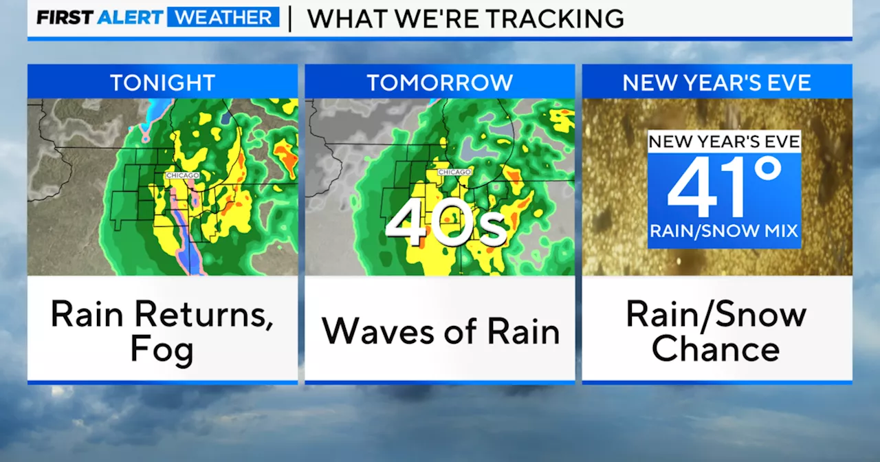 Chicago Weather: Rain and Fog Expected Through SundayThe Chicago area will see rain and fog throughout the weekend, with heavier rainfall in northwest Indiana. Strong winds are also expected on Sunday.
Read more »
 Dense Fog Expected Sunday and Monday MorningDense fog is predicted to become an issue late Sunday and early Monday morning. Temperatures will be in the mid-60s Sunday evening, dropping to the mid-50s Monday morning. Skies will be mostly clear during the day with temperatures reaching the upper 70s.
Read more »
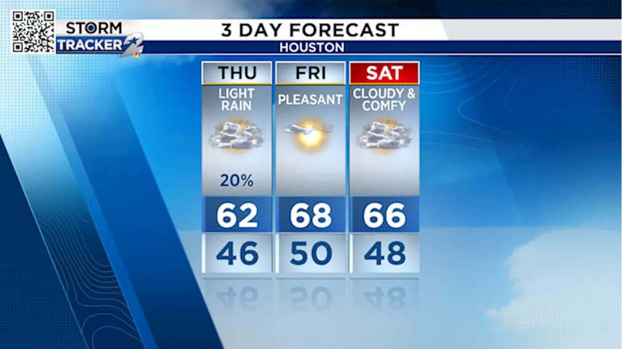 Houston Weather Forecast: Light Rain Today, Severe Threat Sunday, Snow Possible Next WeekExpect light rain showers today mainly south of I-10. Pleasant weather is predicted for Friday and Saturday. A severe weather threat is possible Sunday, mainly northeast of Houston. There's a chance of snow next week, particularly north of I-10.
Read more »
 Heavy Snow Expected Sunday into MondayA winter storm is forecast to bring significant snowfall to Ohio starting Sunday afternoon, with heavier accumulations expected in central and southern regions. Northern Ohio will see lighter snow, while the southern areas may experience a mix of sleet and freezing rain, potentially reducing snowfall totals. Temperatures will remain cold throughout the week, with brisk winds further complicating snow removal efforts.
Read more »
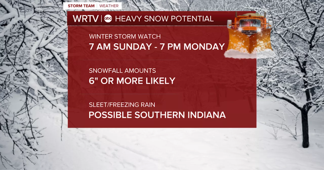 Winter Storm Watch Issued for Sunday and MondayHeavy snow, freezing rain, and sleet possible.
Read more »