
Over 6 million people in the tri-state area are under winter weather alerts and advisories, with a Winter Storm Warning in effect. This storm is expected to bring all snow to the region, with the highest totals expected in the South Jersey area. The snow is expected to start between 4 p.m. and 7 p.m. on Tuesday, with the heaviest snowfall occurring in the evening and overnight hours.
More than 6 million people in the tri-state area are under winter weather alerts and advisories, including a Winter Storm Warning. This storm is expected to bring all snow to the region with the highest totals to our south. At Camden County Public Works in Lindenwold, New Jersey , they have tons of salt and they know how to use it! Unlike the last few storms, this one is expected to bring all snow to the region with the highest totals to our south.
\At the public works complex in Lindenwold, more than 100 pieces of equipment are available to keep county roadways passable. There are 12 winter maintenance districts throughout Camden County to salt and plow, and about 1,200 lane miles to cover. The snow is expected to start between 4 p.m. and 7 p.m. on Tuesday, with it really picking up in the evening and overnight hours, which is when conditions will be at their worst. Commercial vehicle restrictions on multiple interstate highways in New Jersey go into effect Tuesday at 4 p.m. It applies to all tractor-trailers, empty straight CDL-weighted trucks, passenger vehicles pulling trailer, recreational vehicles and motorcycles. \The restrictions, however, do not apply to the New Jersey Turnpike, the Garden State Parkway or the Atlantic City Expressway. Trucks that are already in New Jersey when the travel restrictions go into place are encouraged to pull off in truck stops to wait out the storm. However, they are advised to not park on the shoulders of roadways. Drivers are urged to avoid or delay unnecessary travel Tuesday night into Wednesday, with residual effects expected for the morning commute. The steadiest of snow is expected to fall in Delaware and South Jersey between 8 p.m. on Tuesday and 1 a.m. on Wednesday. The snow exits from NW to SE between 2 a.m. and 5 a.m. on Wednesday but there will be lingering impacts, according to Action News meteorologists. The second system features mainly rain through South Jersey and Delaware. A wintry mix is likely northwest of I-95 initially before transitioning to rain. The storms are expected to move out just in time for Valentine's Day, and more importantly, the Eagles Super Bowl parade
WINTER STORM SNOW NEW JERSEY DELAWARE PENNSYLVANIA TRAVEL RESTRICTIONS PUBLIC WORKS CAMDEN COUNTY
United States Latest News, United States Headlines
Similar News:You can also read news stories similar to this one that we have collected from other news sources.
 Winter Storm to Bring Snow, Frigid Temperatures to New York City and Tri-State AreaA winter storm is expected to bring snow to New York City and the surrounding Tri-State area on Sunday, followed by a period of extremely cold temperatures. Sanitation crews are preparing to clear snow and city officials are urging residents to take precautions.
Read more »
 Winter Storm to Bring Hazardous Travel Conditions to NYC and Tri-State AreaA winter storm is set to bring snow, ice, and rain to New York City and the Tri-State area on Thursday, making travel treacherous. The storm will transition from snow to sleet and freezing rain before finally becoming all rain. Authorities are urging motorists to exercise extreme caution.
Read more »
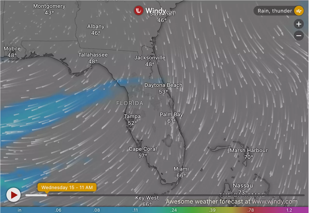 Winter Storm to Bring Rare Frost and Freezing Temperatures to FloridaA winter storm is expected to bring heavy rain, frost, and freezing temperatures to Florida, with Gainesville experiencing temperatures well below average. The NWS has issued a Frost Advisory, warning of potential damage to sensitive vegetation.
Read more »
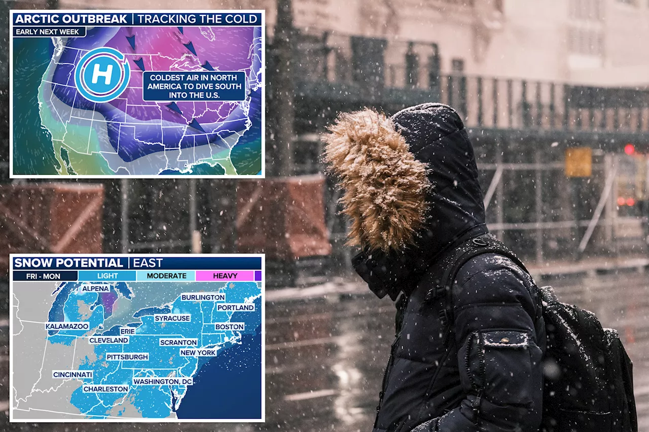 Winter Storm to Bring Snow and Ice to Eastern US, Followed by Dangerous ColdA winter storm system is expected to bring a mix of snow and ice to the eastern US, with the potential for travel disruptions. The storm will be followed by a significant drop in temperatures, with dangerous cold expected in much of the country.
Read more »
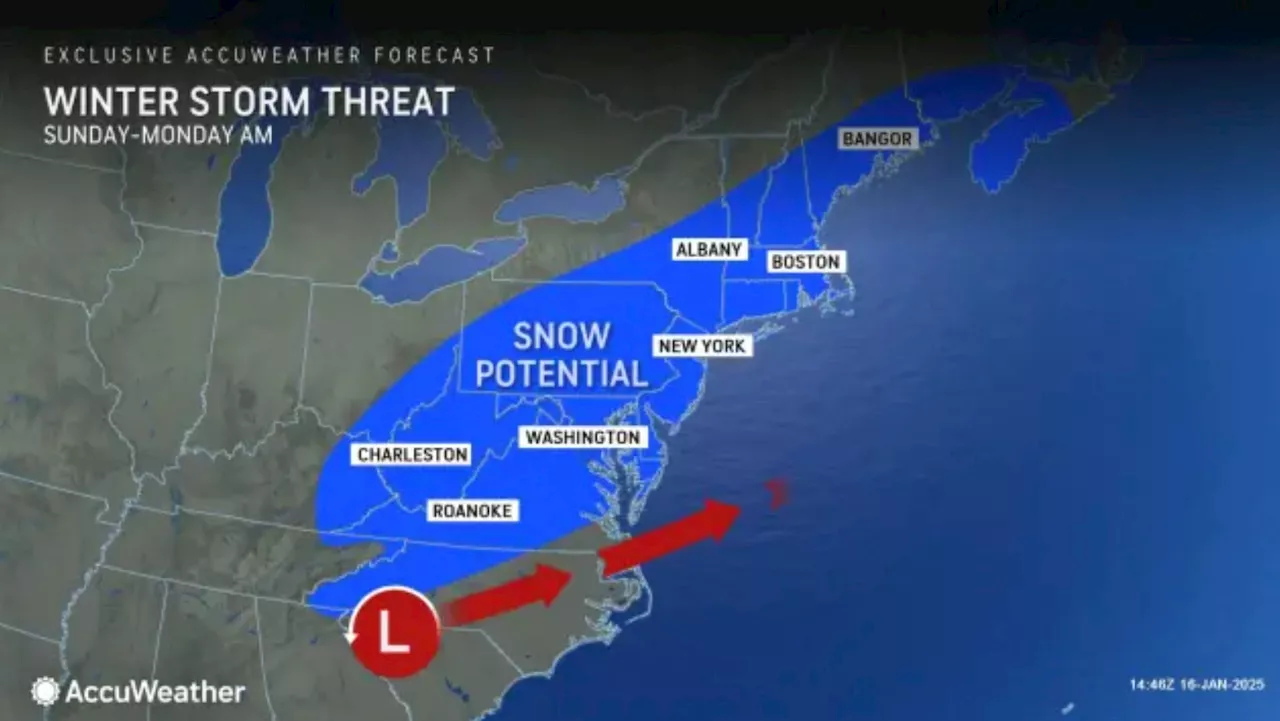 Potential Winter Storm Could Bring Snow to New Jersey This WeekendForecasters predict accumulating snow in New Jersey on Sunday, January 19th, with the potential for 3 to 6 inches. The NWS Mount Holly office has increased confidence in the possibility of snowfall, particularly for areas along the I-95 corridor and points north and west.
Read more »
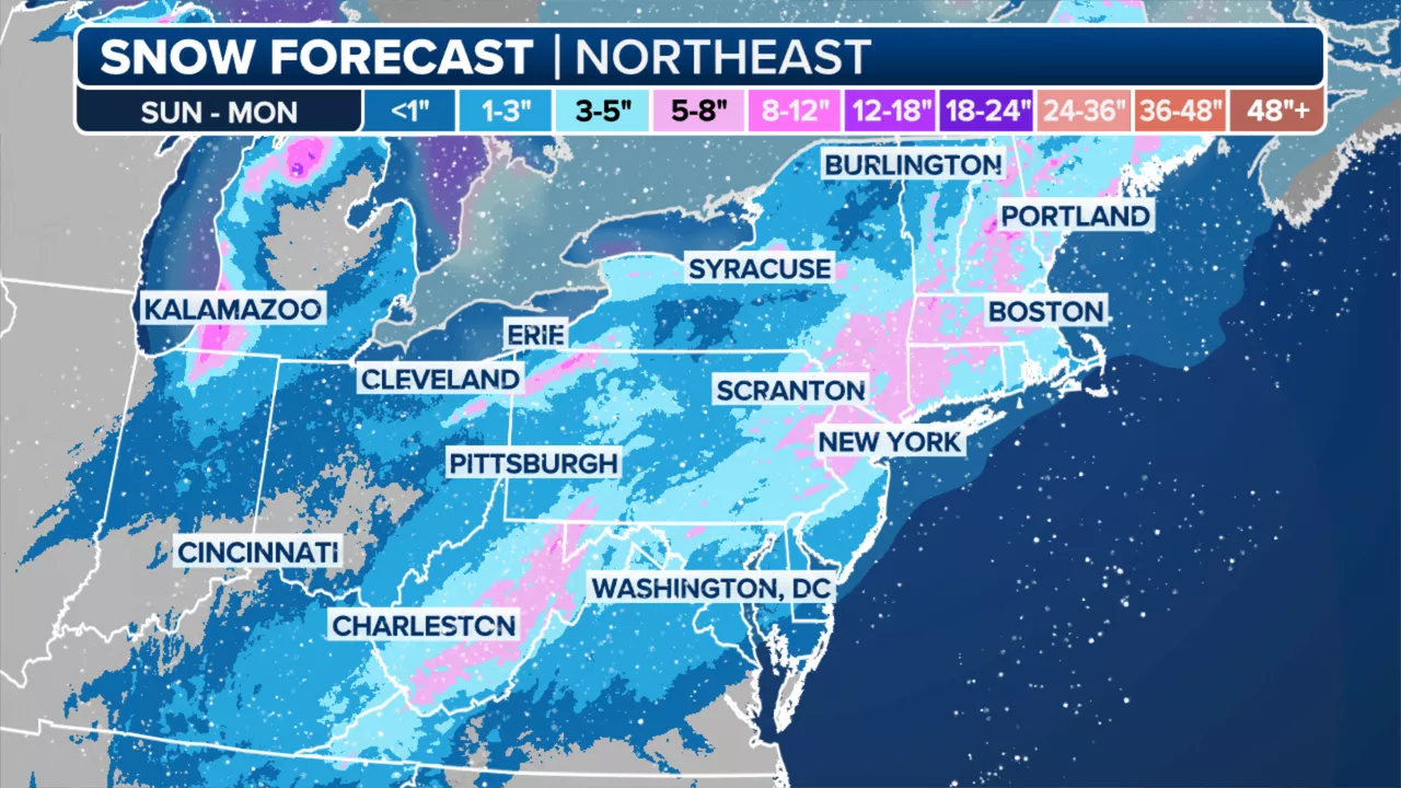 Winter Storm to Bring Heavy Snow and Dangerous Cold to NYCA winter storm is expected to bring significant snowfall to the New York City area on Sunday, followed by a dangerous blast of arctic air with wind chills as low as -15 degrees. The storm is predicted to bring 2 to 5 inches of snow to NYC, with the suburbs seeing 5 to 8 inches. Temperatures will plummet as much as 45 degrees below average, leading to below-zero temperatures across the Northeast.
Read more »