
Tropical Depression 'Kristine' slightly decelerated and maintained its strength while moving west-southwestward over the Philippine Sea, according to the
Tropical Depression “Kristine” slightly decelerated and maintained its strength while moving west-southwestward over the Philippine Sea, according to the 5 p.m. bulletin of state weather bureau PAGASA on Monday.
“Kristine” was moving westward at 15 kilometers per hour with maximum sustained winds of 55 kph near the center and gustiness of 70 kph. Its eye’s center was last estimated 760 kilometers east of Catarman, Northern Samar.The tropical depression could intensify into a tropical storm in the next 12 hours, a severe tropical storm on Wednesday, and a typhoon on Thursday before making landfall.
“Since this tropical cyclone is still over the Philippine Sea, rapid intensification is not ruled out given the favorable environmental conditions,” PAGASA reported. Meanwhile, tropical cyclone wind signal no. 1 was raised over the southeastern portion of Isabela , Aurora, the northern and eastern portions of Quezon including Pollilo Islands, Camarines Norte, Camarines Sur, Catanduanes, Albay, Sorsogon, and Masbate, including Ticao Island and Burias Island, Eastern Samar, Northern Samar, Samar, Leyte, Biliran, Southern Leyte, Dinagat Islands and Surigao del Norte including Siargao – Bucas Grande Group.
United States Latest News, United States Headlines
Similar News:You can also read news stories similar to this one that we have collected from other news sources.
 Tropical Depression Julian barely moving over Philippine SeaPAGASA sees Tropical Depression Julian following a 'looping path' over the waters east of Batanes and Cagayan. But even without making landfall, it will affect Northern Luzon.
Read more »
 Tropical Storm Julian slightly intensifies over Philippine SeaThe maximum sustained winds of Tropical Storm Julian (Krathon) increase to 75 km/h on Saturday afternoon, September 28
Read more »
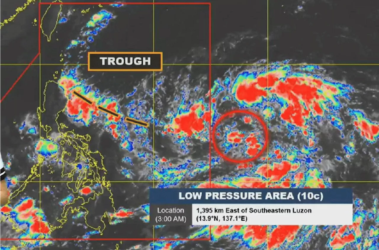
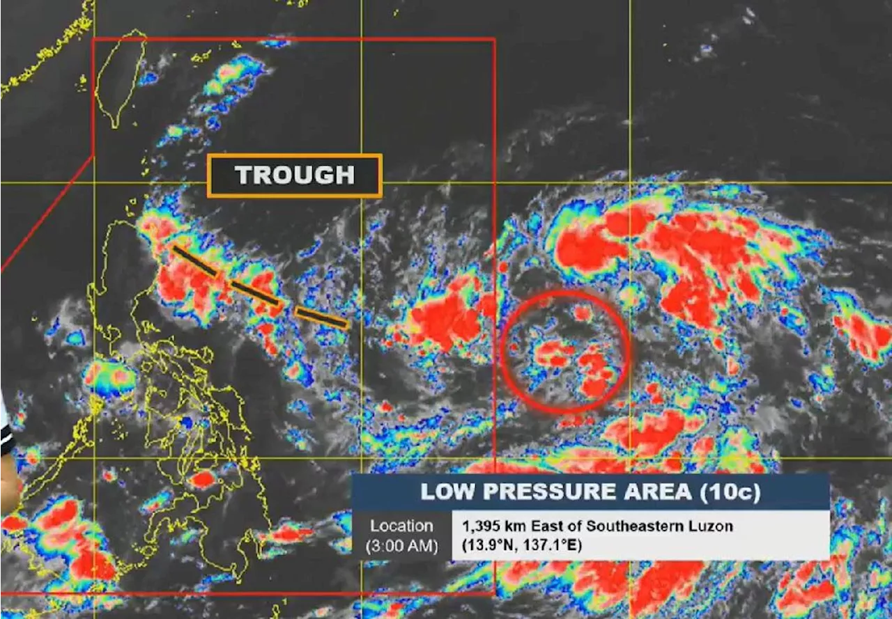 Low-Pressure Area East of Luzon May Develop Into Tropical Depression KristineA low-pressure area (LPA) located east of Southern Luzon is forecast to enter the Philippine Area of Responsibility (PAR) on Sunday and has a high chance of developing into a tropical depression within 24 hours. The LPA's trough will bring rains over parts of Luzon, with possible landfall in Northern and Central Luzon. Meanwhile, other areas will experience scattered showers due to the Intertropical Convergence Zone.
Read more »
 LPA expected to enter PAR, develop into tropical depression to be named 'Kristine'MANILA, Philippines — The state-run weather agency said on Sunday that a low pressure area (LPA) was expected to enter the Philippine Area of Responsibility (PAR) anytime within the day and would develop into a tropical depression to be named 'Kristine.
Read more »
 Philippines braces for 'Kristine', 11th tropical cyclone of the yearDefense Secretary Gilberto Teodoro Jr. urged Filipinos to take early precautions as a new weather disturbance, expected to develop into a tropical depression named 'Kristine,' is predicted to enter the Philippine Area of Responsibility (PAR). The impending cyclone could affect over a million people and bring moderate to heavy rainfall starting Tuesday.
Read more »
 Tropical Depression Kristine enters PARThe regions of Bicol and Eastern Visayas as well as the province of Quezon have moderate to heavy rain from Tropical Depression Kristine on Monday, October 21. Signal No. 1 is also up in a few areas as of 5 am.
Read more »