
First Alert Weather: Tomorrow, everyone is expected to see rain, some will see a little snow mixing in, and breezy north winds will have us feeling like we're in the 30s.
– We've been precip free for the month of January but that all comes to an end Tuesday.
We've issued a First Alert Weather Day for Tuesday. It will be a cold, windy, dreary day. Everyone is expected to see rain, some will see a little snow mixing in, and breezy north winds will have us feeling like we're in the 30s.We're expecting widespread rain to start moving in for the morning commute Tuesday, moving in from west to east. Heavy rain will be possible at times so make sure that you plan extra time for your morning and evening commutes.
A Winter Weather Advisory goes into effect at noon Tuesday – this is where snow accumulation is most likely, and where some minor travel impacts are expected. The Winter Weather Advisory doesn't include the metroplex but it does include the Red River counties and our northwest counties. Accumulations will mainly be on grassy and elevated surfaces, but some slushy roads are also a possibility to the north and west.
United States Latest News, United States Headlines
Similar News:You can also read news stories similar to this one that we have collected from other news sources.
 First Alert Weather: Yellow Alert for rain, wintry mix starting Sunday afternoonWe have a Yellow Alert in place from Sunday afternoon through Monday afternoon.
Read more »
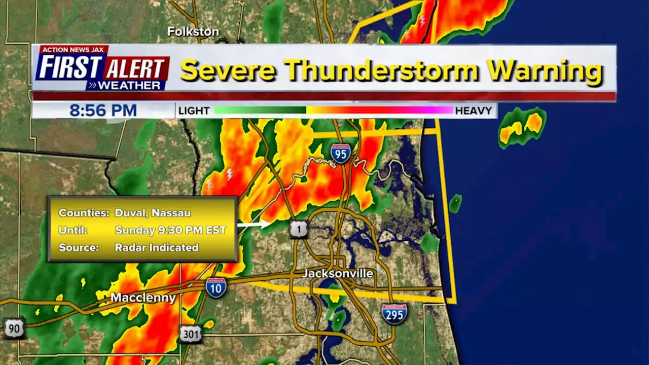 Jacksonville, Northeast Florida, Southeast Georgia Interactive Radar | First Alert Weather | Action News Jax – Action News JaxThe National Weather Service in Jacksonville has issued a\n\n* Severe Thunderstorm Warning for...\nCentral Nassau County in northeastern Florida...\nDuval County in northeastern Florida...\n\n* Until 930 PM EST.\n\n* At 851 PM EST, severe thunderstorms were located along a line\nextending from Yulee to near Ratliff to near Bryceville, moving\neast at 45 mph.\n\nHAZARD...70 mph wind gusts.\n\nSOURCE...Radar indicated.\n\nIMPACT...Expect considerable tree damage. Damage is likely to\nmobile homes, roofs, and outbuildings.\n\n* Locations impacted include...\nJacksonville International Arpt, Unf, Arlington, Jacksonville\nBeach, Atlantic Beach, Yulee, Neptune Beach, Cisco Gardens, San\nPablo and Fort Caroline.
Read more »
 STORMS ON THE WAY: Strong to severe weather expected in Houston on TuesdayWidespread showers and storms are expected throughout Southeast Texas on Tuesday as a low pressure system and cold front move through the area.
Read more »
 North Texas roadway authorities, cities prepare for winter weather on TuesdayThe winter weather could impact travel on Tuesday, with cold rain during the morning commute and the potential for snow on the drive home.
Read more »