Very heavy rain, strong to severe storms and gusty winds are expected to impact the area.
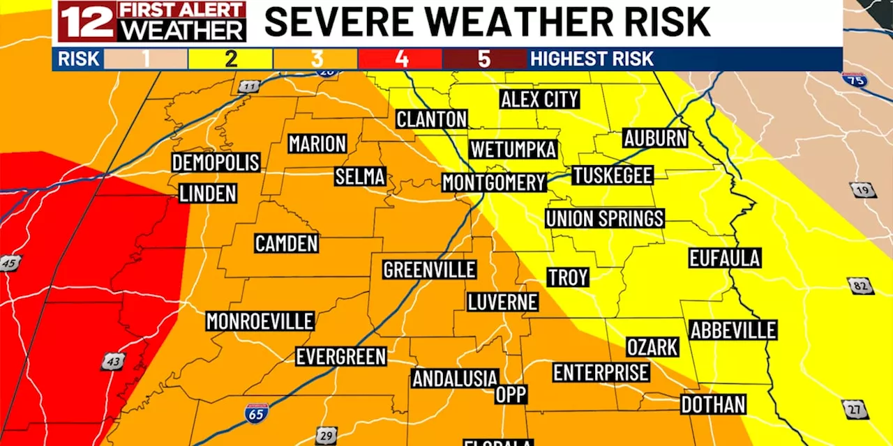
The WSFA 12 News First Alert Weather team has declared Wednesday through Wednesday night a First Alert Weather Day. This is due to a highly impactful system that will move across the state. Central Alabama is in either a level 2 or 3 out of 5 risk of severe weather Wednesday - Wednesday night.
Today will be much less impactful with nothing more than some harmless sprinkles and scattered rain showers under a mainly cloudy sky. Highs will reach the middle 70s this afternoon. A lull in the rain will occur tonight before our major storm system arrives from the west through the afternoon tomorrow. That system will bring widespread very heavy rain, thunderstorms and windy conditions tomorrow afternoon through as late as sunrise Thursday. Flash flooding and severe storms are likely to be involved too.Most of Alabama is projected to pick up anywhere between 2 and 5 inches of rainfall with this system. As a result of this, the Weather Prediction Center continues to have most of Central Alabama in a level 3-of-4 “high risk” of excessive rainfall. This risk level is not all that common and means that heavy rain leading to flash flooding is possible, if not likely, during this event. As always, remember to download the free WSFA 12 First Alert Weather app. That way you can gain the latest weather information from the First Alert Weather Team wherever you go. Just search WSFA Weather in the Apple App Store or Google Play store today.There is also an areawide risk of severe thunderstorms. The Storm Prediction Center includes areas generally west of Montgomery in a level 3-of-5 risk and everyone else in a level 2-of-5 risk of severe weather. This is mainly for late Wednesday afternoon through late Wednesday night. The risks include damaging wind gusts, tornadoes and plenty of lightning.More details regarding the extent, timing and severity of the storms will be available as we progress through the day today, so be sure to keep checking back! In addition to the heavy rain and severe weather risks, there will also be plenty of wind ahead. Late Wednesday through most of Thursday will be the windiest period. We’ll deal with wind speeds of 15-25 mph and wind gusts of 30-40 mph. Winds of this magnitude could lead to power outages due to the wet ground.A few showers may rotate through the area Thursday as the system departs. Otherwise it will be mostly cloudy and windy. The wind stays elevated on Friday, but skies will be entirely sunny with highs in the lower 70s. The weekend will follow suit on a beautiful note with highs in the upper 70s and lower 80s with plenty of sunshine. Low 80s and sunshine will continue into early next week!
United States Latest News, United States Headlines
Similar News:You can also read news stories similar to this one that we have collected from other news sources.
 First Alert Weather: Yellow Alert for NYC and N.J. wind; N.J. river flooding concernsYellow Alert today due to strong winds that could take down tree limbs and result in power outages.
Read more »
 Cooler air returns Wednesday and another hard freeze Wednesday night | Live Doppler 13 Weather BlogIt is the first full day of spring and, oddly enough, it feels like winter in Indiana.
Read more »
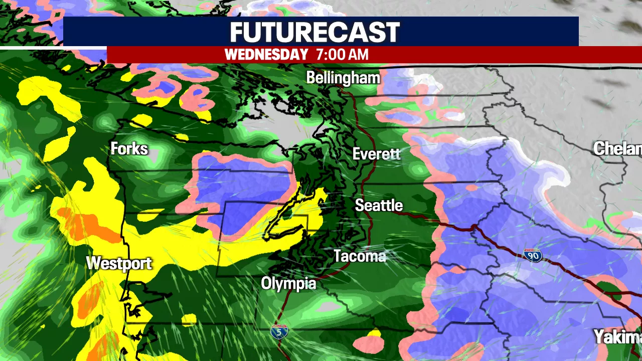 Seattle weather: Stormy weather ahead for WednesdayTuesday will bring scattered showers, clouds, and sunshine to Western Washington, with stormier weather set to hit early Wednesday morning.
Read more »
 Weather Impact Day versus a Weather Alert DayWeather Impact Day versus a Weather Alert Day
Read more »
 Northeast Ohio weather: First ALERT Weather Day issued for Monday into TuesdaySeveral rounds of rain are expected over the next few days.
Read more »
 Weather Alert Day through Wednesday afternoon for strong to severe stormsToday is a Weather Authority Alert Day as strong and severe storms are expected to impact parts of Northeast Florida and Southeast Georgia.
Read more »