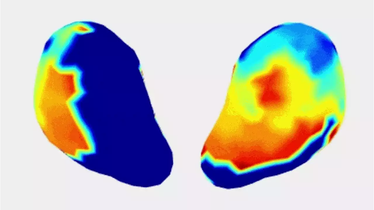
Tool has the potential to assist with preterm birth, labor management and clinical decision-making. Researchers funded by the National Institutes of Health have developed a new imaging tool, called electromyometrial imaging (EMMI), to create real-time, three-dimensional images and maps of contrac
Researchers at Washington University School of Medicine in St. Louis have developed a new imaging method to produce detailed 3D maps of uterine contractions in real-time. The technology could help define the progression of healthy labor and identify when problems may be developing, such as in preterm labor or labor arrest. Shown is a video clip of the left and right view of the real-time progression of a single uterine contraction during normal labor.
The study team, led by Yong Wang, Ph.D., and Alan Schwartz, M.D., Ph.D., at Washington University in St. Louis, and Alison Cahill, M.D., at the University of Texas at Austin, initially developed EMMI using a sheep model and reported their findings in. In the new study, the team tailored EMMI for human clinical use and tested it among a group of 10 women with healthy pregnancies.
EMMI maps were also used to develop metrics to describe uterine contractions. The maximal activation ratio, for example, measures the total surface area of the uterus that becomes electrically active during an individual contraction. The activation curve slope measures the rate of uterine electrical activation. The fundal early activation ratio helps quantify the region that generates contractions to dilate the cervix.
United States Latest News, United States Headlines
Similar News:You can also read news stories similar to this one that we have collected from other news sources.
 Speaking to State Lawmakers, Dallas Leaders Promote Overdose Mapping That City Hall ResistedAs the dangerous drug fentanyl causes deaths and overdoses across North Texas, a new prevention method is gaining support from Texas lawmakers.
Read more »
 Mapping expert analyzes where flood zones could beA flood plain risk maps show what areas are at risk for potential flooding.
Read more »
 Experts reveal digital image of what an Egyptian man looked like almost 35,000 years ago'If a man of that time could walk down the street, people would not see any difference': Digital imaging reveals the face of an Egyptian man who lived 35,000 years ago
Read more »
 FDA ruling: What is mifepristone?Mifepristone blocks a hormone called progesterone, which helps the body maintain the inside of the uterus so a pregnancy can continue. A healthy uterine lining is what supports a fertilized egg, em…
Read more »
 New report shows extent of chemical release from Martinez refineryBay Area air quality regulators have released a new report mapping the areas affected by a chemical release from a Martinez refinery last year, and the results have prompted prosecutors to review the violations discovered for possible charges against the refinery.
Read more »
 Seismic Sleuths Reveal Earth’s Secret Mountains: A Hidden World Beneath Our FeetResearchers from The University of Alabama discovered a dense layer of ancient ocean floor, or ultra-low velocity zone (ULVZ), between Earth's core and mantle using seismic imaging. These underground 'mountains' could play a key role in heat escape from the core and the planet's magnetic field. T
Read more »