An Arctic cold front will bring a dramatic temperature drop to the region starting Sunday, following mild temperatures in the 60s on Friday and Saturday. The high for Sunday will occur early in the morning, with temperatures dropping sharply into the 40s and 30s by midday.
An Arctic cold front arrives midday Sunday after temperatures in the 60s on Friday and Saturday.Any wintry precipitation would be light, and there's only a low chance of precipitation falling. We knew it would happen sooner or later - the return of Arctic air! That return will bring a dramatic weather change late this weekend.Here's how the forecast is shaping up. Friday and Saturday will feature the last'mild' weather before Sunday's cold front .
While Friday will feature partly to mostly sunny skies, clouds can be expected on Saturday. Some drizzle is possible with Saturday's cloud cover, but most of the day should be dry. Saturday's high will be near 60. The day of transition will be Sunday. While a few hours will be mild in the morning, most of the day is expected to be in the 40s. Use the slider in the image below to see how the temperature is expected to change throughout the day.As the cold front approaches Sunday, there's a slight chance for a brief shower in the morning. The better chance for rain will be over in East Texas. Otherwise, the bigger story will be the dramatic temperature drop. Our high Sunday will occur early in the morning in the 60s. The mild morning will be short-lived as temperatures drop sharply into the 40s and 30s by midday. A strong north wind will push wind chills down into the 20s by late in the day.While most of the emphasis is on the cold temperatures, there's a slight chance for some wintry precipitation toward the middle of next week (Wednesday and Thursday). There is only a slight chance of precipitation at this time, and it looks to be light (if it occurs). Of course, we'll closely monitor things, so stay tuned for updates.Before the cold, replace worn weatherstripping on doors and windows to ensure a good seal. This will make sure warm air stays inside and cold air stays outside. Most modern windows are sealed inside the frame, but older windows may be sealed with a glaze that can crack and need replacin
Arctic Air Cold Front Temperature Drop Wintry Precipitation Weather Forecast
United States Latest News, United States Headlines
Similar News:You can also read news stories similar to this one that we have collected from other news sources.
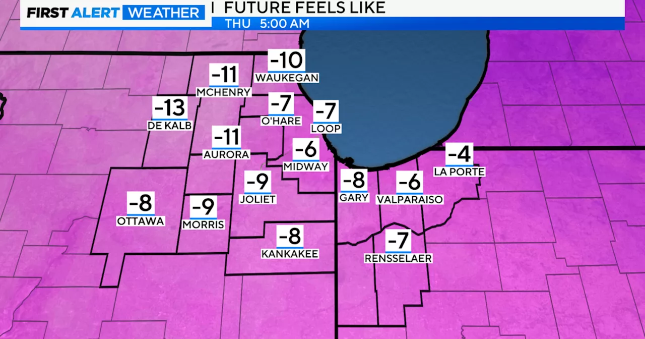 Arctic Cold Front Brings Gusty Winds and Snow Showers to ChicagoAn arctic cold front has brought powerful wind gusts and scattered snow showers to the Chicago area. Wind gusts reached up to 62 mph in Gary and 58 mph in Aurora and at Midway International Airport. Snow squalls may cause slick spots and reduced visibility. Wind chills Thursday morning will be between -5 and -15 degrees.
Read more »
Warm Sunday in South Texas; strong cold front takes aim midweekHigh temperatures will be about 10 degrees above average on Sunday, and low temperatures will be nearly 25 degrees above average.
Read more »
 Arctic Front to Bring Chilling Temperatures to North TexasAn Arctic winter front has brought snow and freezing temperatures to North Texas. A cold front is expected to continue chilling Dallas-Fort Worth through the weekend, with the potential for an even stronger Arctic front next week.
Read more »
 Lake-effect snow warning in effect as Arctic front approachesThe National Weather Service says the cold front will generate 5 to 10 inches of snow in eastern and southern Cuyahoga County, and in Geauga, southern Lake, northern Summit, and northern Portage counties, as well as northwestern Trumbull County.
Read more »
 Arctic tundra becoming source of carbon dioxide emissions2024 Arctic Report Card tracks rapid, complex Arctic change
Read more »
 2024 Arctic Report Card reveals a concerning trend in Arctic nationsThe Arctic saw the second warmest year on record since 1900.
Read more »